
Found 20 datasets matching filters.
-
The grizzly bear distribution boundary delineates the estimated geographic extent of occupied range of the Yellowstone grizzly bear population for the period 2000-2014. The distribution boundary...
Search relevance: 1.00 | Views last month: 1 | Published on: 2026-03-03 -
Well construction data for 11,917 domestic and 2,390 public-supply wells in the Central Valley were compiled as part of the U.S. Geological Survey (USGS) National Water Quality Assessment Project...
Search relevance: 1.00 | Views last month: 1 | Published on: 2026-03-03 -
These data include 217 median groundwater elevations computed from compiled measurements made in the year 2010 within the transboundary Mesilla/Conejos-Médanos Basin, United States and Mexico,...
Search relevance: 1.00 | Views last month: 1 | Published on: 2026-03-03 -
Bottom altitudes of the Mississippi River Valley alluvial aquifer (MRVA) were compiled from interpretations of subsurface geophysical logs (log picks) at about 10,000 boreholes and wells located...
Search relevance: 1.00 | Views last month: 0 | Published on: 2026-03-03 -
The maps in this submission include: heat flow, alkalinity, Cl, Mg, SiO2, Quaternary volcanic rocks, faults, and land ownership. All of the Oregon Cascade region. The work was done by John...
Search relevance: 1.00 | Views last month: 0 | Published on: 2026-01-27 -
This data set contains standard error in the kriging prediction of estimated yield of bedrock wells in grid cells of 200x200 meters in the Nashoba Terrane and surrounding area, central and eastern...
Search relevance: 1.00 | Views last month: 0 | Published on: 2026-03-03 -
This data set archives all inputs, outputs and scripts needed to reproduce the findings of W.H. Farmer and G.F. Koltun in the 2017 Journal of Hydrology Regional Studies article entitled...
Search relevance: 1.00 | Views last month: 0 | Published on: 2026-03-03 -
Site data contained in the ScrIntrvls_AllSrcRefs_AllWellsRev.csv dataset define the top and bottom altitudes of well screens in 64,763 irrigation wells completed in the Mississippi River Valley...
Search relevance: 1.00 | Views last month: 0 | Published on: 2026-03-03 -
The base flow recession time constant (tau) is a hydrologic index that characterizes the ability of a ground-water system to supply flow to a stream draining from that system. Tau and other...
Search relevance: 1.00 | Views last month: 0 | Published on: 2026-03-03 -
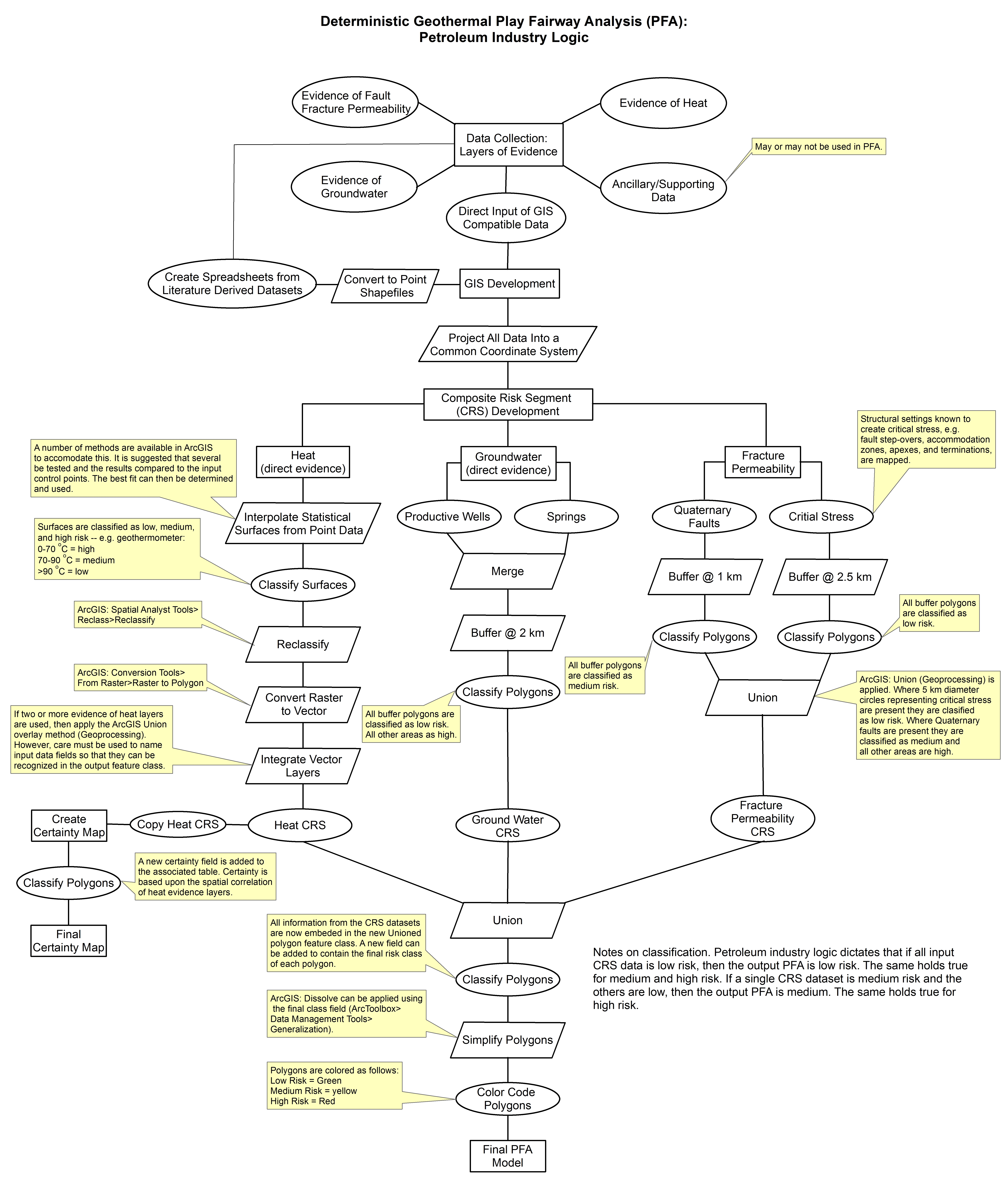
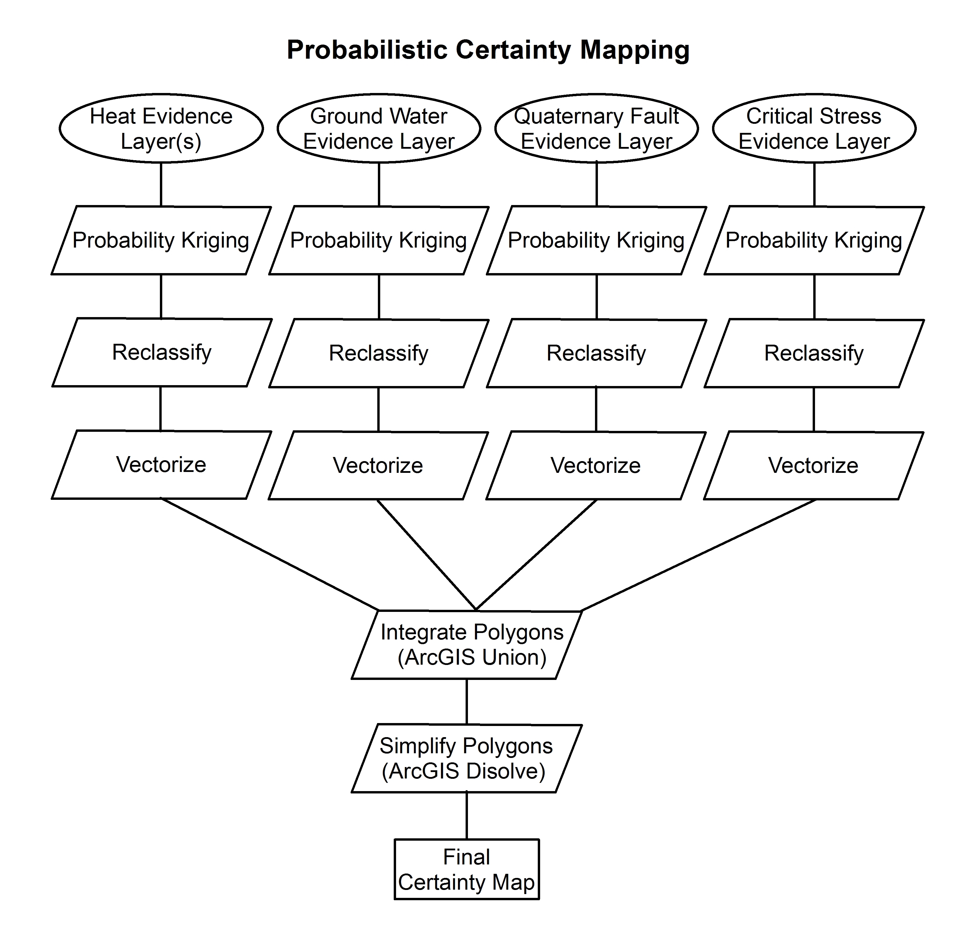
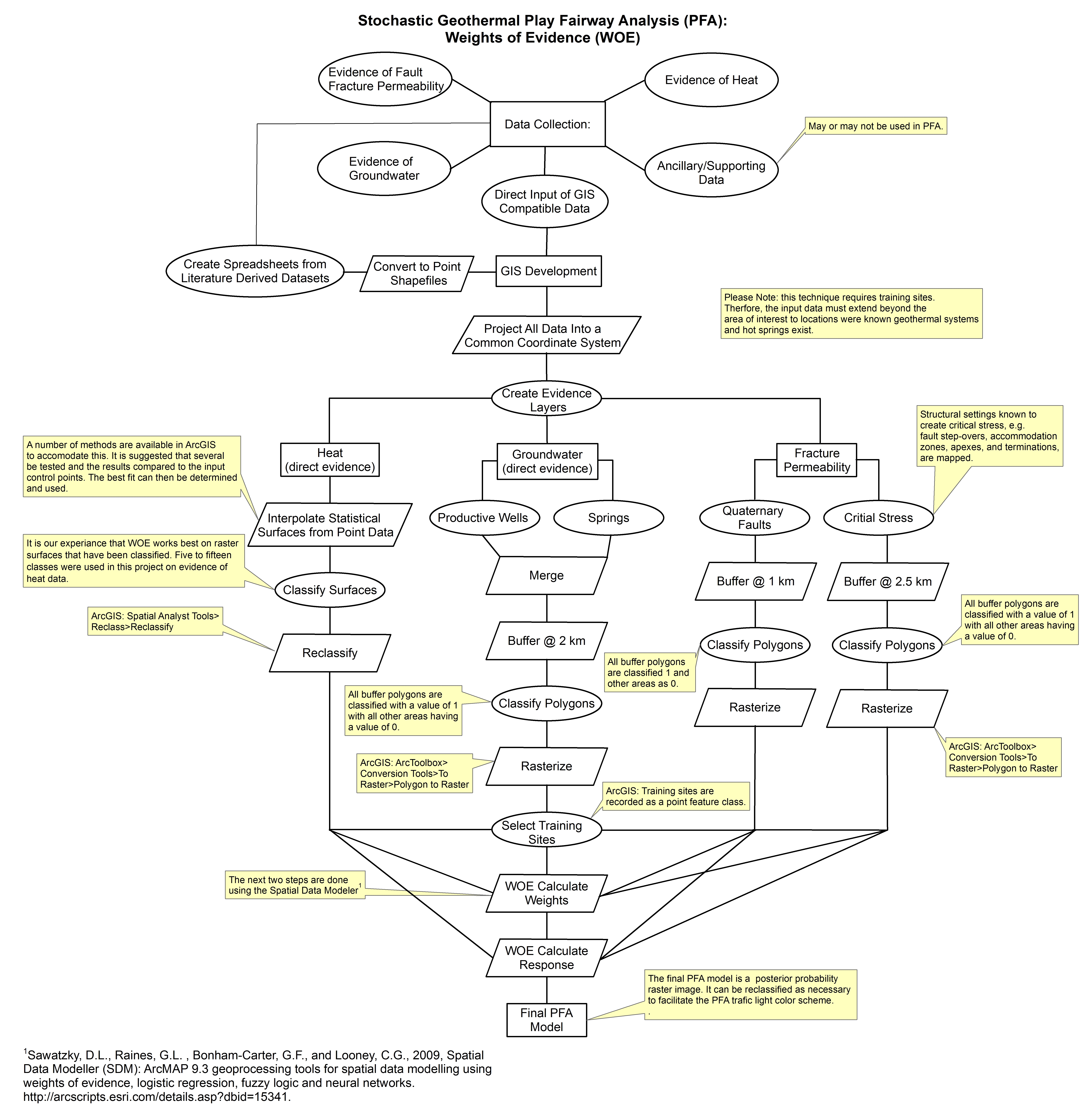
This collection of files are part of a larger dataset uploaded in support of Low Temperature Geothermal Play Fairway Analysis for the Appalachian Basin (GPFA-AB). Phase 1 of the GPFA-AB project...
Search relevance: 1.00 | Views last month: 0 | Published on: 2026-01-27 -
These images show the comprehensive methodology used for creation of a Play Fairway Analysis to explore the geothermal resource potential of the Tularosa Basin, New Mexico. The deterministic...
Search relevance: 1.00 | Views last month: 0 | Published on: 2026-01-27 -
This dataset contains base-flow recession time constant (tau) contours that are interpreted from tau values calculated at streamgages in the Niobrara National Scenic River study area. The contours...
Search relevance: 1.00 | Views last month: 0 | Published on: 2026-03-03 -
Data for generating statistical maps of soil cobalt concentrations in the conterminous United States
The product data are six statistics that were estimated for the chemical concentration of cobalt in the soil C horizon of the conterminous United States (Smith and others, 2013). The estimates are...
Search relevance: 1.00 | Views last month: 0 | Published on: 2026-03-03 -
The product data are six statistics that were estimated for the chemical concentration of lithium in the soil C horizon of the conterminous United States. The estimates are made at 9998 locations...
Search relevance: 1.00 | Views last month: 0 | Published on: 2026-03-03 -
This submission includes a fault map of the Oregon Cascades and backarc, a probability map of heat flow, and a fault density probability layer. More extensive metadata can be found within each zip...
Search relevance: 1.00 | Views last month: 0 | Published on: 2026-01-27 -
[Note, 1/20/2026: Farm management PDF files added.]The USDA Beltsville Agricultural Research Center (BARC) Gridded Yield Data Archive is a multi-year, gridded yield data archive derived from yield...
Search relevance: 1.00 | Views last month: 0 | Published on: 2026-02-12 -
This data release documents grid cells and modeled groundwater levels for hydrologic characterization of aquifer areas used for public drinking-water supply in California’s Central Valley from...
Search relevance: 1.00 | Views last month: 0 | Published on: 2026-03-03 -
The product data are six statistics that were estimated for the chemical concentration of lanthanum in the soil C horizon of the conterminous United States (Smith and others, 2013). The estimates...
Search relevance: 1.00 | Views last month: 0 | Published on: 2026-03-03 -
This data release contains groundwater elevation data and the associated model/code used to create groundwater elevation surfaces in and around select oil fields in California. The data and model...
Search relevance: 1.00 | Views last month: 0 | Published on: 2026-03-03 -
General repository for spatial data and methods used to create bathymetric maps for the water bodies included in NETN's water quality monitoring protocol. Objective of these surveys was to...
Search relevance: 1.00 | Views last month: 0 | Published on: 2026-03-04
