
Found 60 datasets matching filters.
-
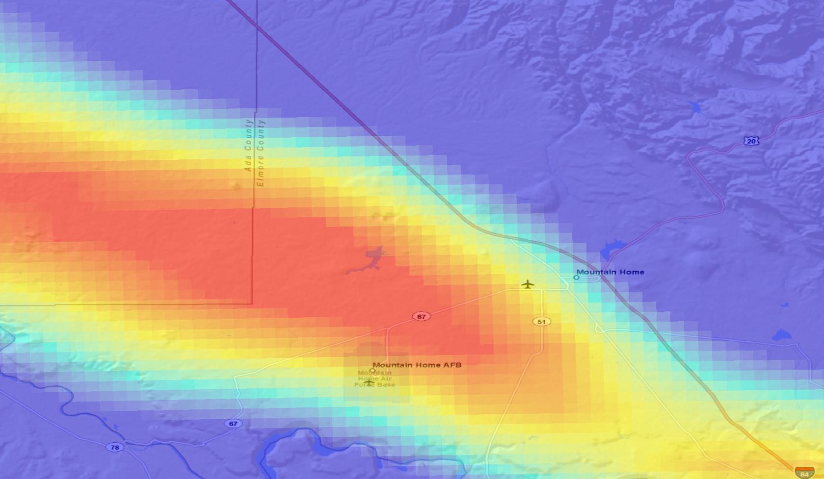
The Mountain Home area is characterized by high heat flow and temperature gradient. Temperature data are available from 18 boreholes with depths equal to or greater than 200 m, 5 of which have...
Search relevance: 1.00 | Views last month: 3 | Published on: 2026-03-23 -
The dataset provides a spatially explicit estimate of 2019 herbaceous annual percent cover predicted on May 1st with an emphasis on annual grasses. The estimate is based on the mean output of two...
Search relevance: 1.00 | Views last month: 2 | Published on: 2026-03-03 -
Data includes species cover of cheatgrass (BRTE) and Russian thistle (SATR), as well as functional group cover of Sandberg's bluegrass (POSE), bare ground, litter, and shrubs for the year of 2021.
Search relevance: 1.00 | Views last month: 1 | Published on: 2026-03-03 -
The NNW-striking Madison fault zone is approximately 95 km in length, lying at the confluence of the northeast Basin and Range province and the Yellowstone tectonic parabola. The fault zone...
Search relevance: 1.00 | Views last month: 1 | Published on: 2026-03-03 -
A natural consequence of groundwater withdrawals is the removal of water from subsurface storage, but the overall rates and magnitude of groundwater depletion in the United States are not well...
Search relevance: 1.00 | Views last month: 1 | Published on: 2026-03-07 -
This dataset provides a near-real-time estimate of 2018 herbaceous annual cover with an emphasis on annual grass (Boyte and Wylie. 2016. Near-real-time cheatgrass percent cover in the Northern...
Search relevance: 1.00 | Views last month: 1 | Published on: 2026-03-03 -
Phenological dynamics of terrestrial ecosystems reflect the response of the Earth's vegetation canopy to changes in climate and hydrology and are thus important to monitor operationally. The...
Search relevance: 1.00 | Views last month: 1 | Published on: 2026-03-03 -
This table summarizes land area occuring within unique combinations of sage-grouse management zones, sagebrush community types, soil temperature/moisture regimes, and times burned from 1984 to...
Search relevance: 1.00 | Views last month: 1 | Published on: 2026-03-03 -
This dataset includes magnetotelluric transfer functions in the form of EDI files for 16 stations collected by the USGS and 40 stations collected by Quantec Geoscience for Lawerence Berkeley...
Search relevance: 1.00 | Views last month: 1 | Published on: 2026-03-23 -
Phenological dynamics of terrestrial ecosystems reflect the response of the Earth's vegetation canopy to changes in climate and hydrology and are thus important to monitor operationally. The...
Search relevance: 1.00 | Views last month: 1 | Published on: 2026-03-03 -
This dataset contain raw data files in kmz files (Google Earth georeference format). These files include volcanic vent locations and age, the distribution of fine-grained lacustrine sediments...
Search relevance: 1.00 | Views last month: 1 | Published on: 2026-03-23 -
Data includes functional group cover of annual grasses, perennial grasses and shrubs, and model predicted fire behavior for the years of 2018-2021.
Search relevance: 1.00 | Views last month: 1 | Published on: 2026-03-03 -
Well data for the USGS-142 well located in eastern Snake River Plain, Idaho. This data collection includes lithology reports, borehole logs, and photos of rhyolite core samples. This collection...
Search relevance: 1.00 | Views last month: 0 | Published on: 2026-03-23 -
Project Hotspot applies innovative approaches to geothermal exploration in the Snake River Volcanic Province. This report summarizes results from our Phase 1 data compilation.
Search relevance: 1.00 | Views last month: 0 | Published on: 2026-03-23 -
This presents the results of Phase 1 of the Snake River Plain Play Fairway Analysis project, along with a proposed work for Phase 2. No new data were collected, but we list data sources for our...
Search relevance: 1.00 | Views last month: 0 | Published on: 2026-03-23 -
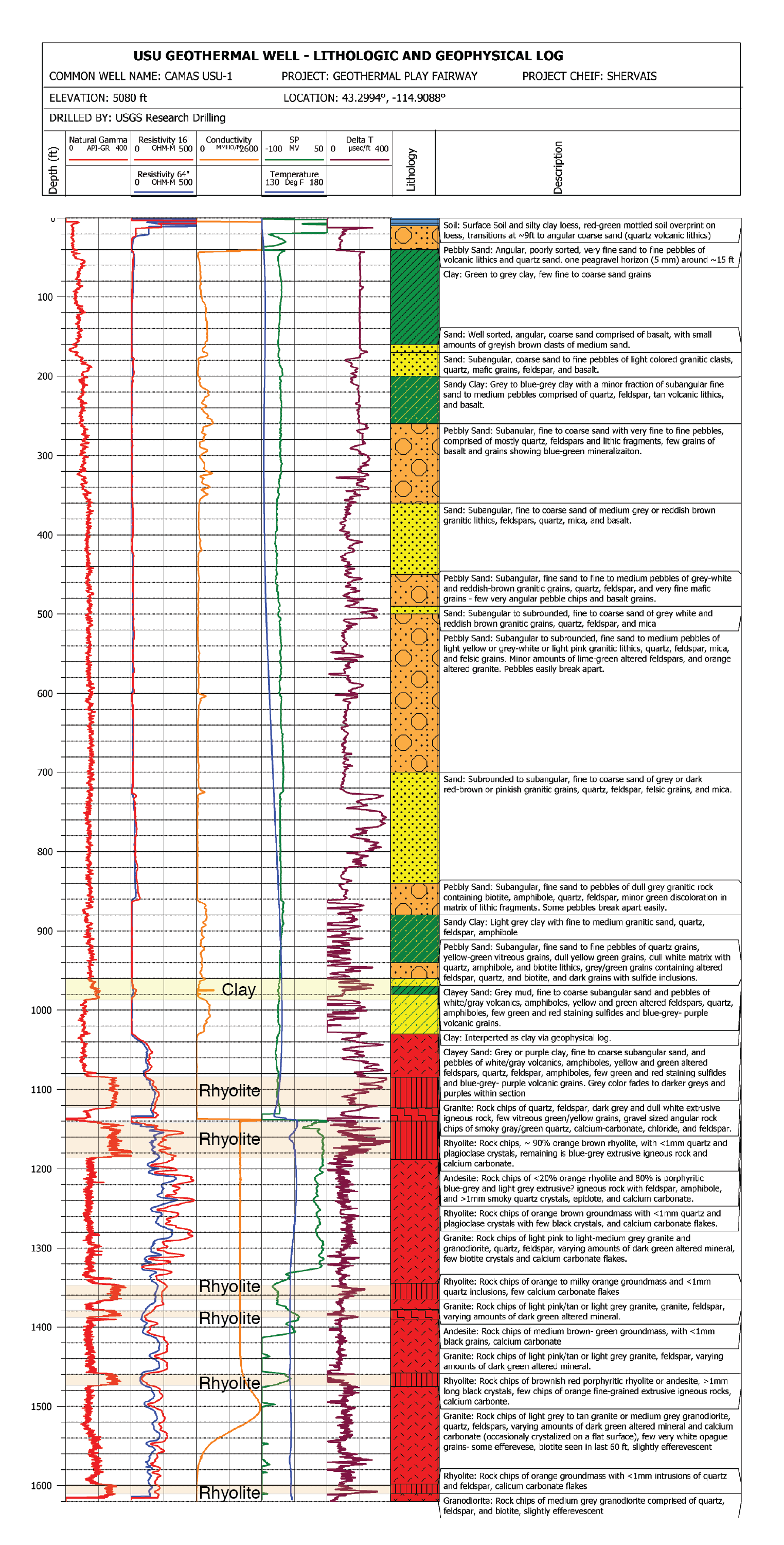
This submission contains documents that describe the USU Camas-1 test well, drilled in Camas Prairie, Idaho, in Fall 2018 and Fall 2019. The purpose of this well is to validate exploration...
Search relevance: 1.00 | Views last month: 0 | Published on: 2026-03-23 -
The northern half of the Lake Walcott 30 x 60 minute quadrangle shows the geology of the southern part of the Craters of the Moon lava field, the complex geologic features of the Holocene Kings...
Search relevance: 1.00 | Views last month: 0 | Published on: 2026-03-03 -
The Snake River Plain (SRP), Idaho, hosts potential geothermal resources due to elevated groundwater temperatures associated with the thermal anomaly Yellowstone-Snake River hotspot. Project...
Search relevance: 1.00 | Views last month: 0 | Published on: 2026-03-23 -
Groundwater in the arid Mountain Home area is vital to agricultural, municipal, industrial and other water users who are concerned about declining groundwater levels. The U.S. Geological Survey,...
Search relevance: 1.00 | Views last month: 0 | Published on: 2026-03-03 -
The site characterization data used to develop the conceptual geologic model for the Snake River Plain site in Idaho, as part of phase 1 of the Frontier Observatory for Research in Geothermal...
Search relevance: 1.00 | Views last month: 0 | Published on: 2026-03-23
