
Found 17 datasets matching filters.
-
This regards a high-resolution DAS microseismic dataset produced by Silixa from Utah FORGE Phase 2C seismic monitoring well 78-32 during stimulation testing of well 58-32. It is a very large...
Search relevance: 1.00 | Views last month: 2 | Published on: 2026-01-27 -
Contains metadata associated with the wells used in the 2016 Spring Campaign led partially by UW - Madison, LBNL, and LLNL scientists. Included with the well coordinates are the depths to the...
Search relevance: 1.00 | Views last month: 0 | Published on: 2026-01-27 -
The EGS Collab is conducting experiments in hydraulic fracturing at a depth of 1.5 km in the Sanford Underground Research Facility (SURF) on the 4850 Level. A total of eight ~60m-long...
Search relevance: 1.00 | Views last month: 0 | Published on: 2026-01-27 -
This submission includes two modeled drawdown scenarios with new supply well locations, a total dissolved solids (TDS) concentration grid (raster dataset representing the spatial distribution of...
Search relevance: 1.00 | Views last month: 0 | Published on: 2026-01-27 -
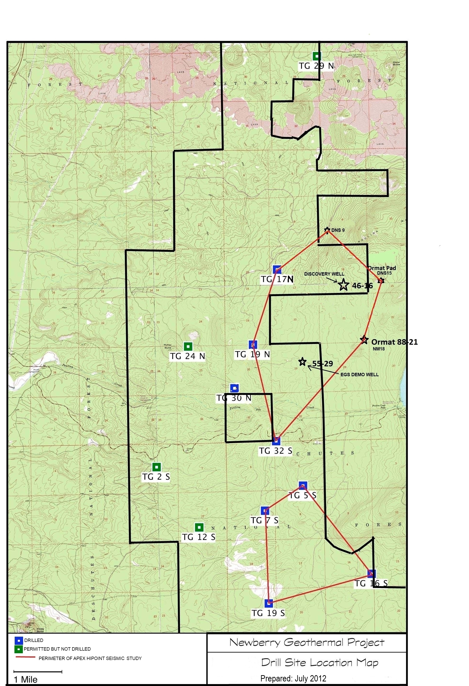
A map showing location of wells permitted, drilled and seismic test, as part of validation of innovative exploration technologies done for the Newberry Volcano project in 2012.
Search relevance: 1.00 | Views last month: 0 | Published on: 2026-01-27 -
Utah FORGE has been established to develop, test, and improve the technologies and techniques required to develop EGS-type geothermal resources. Drilling of the first of two deep deviated wells,...
Search relevance: 1.00 | Views last month: 0 | Published on: 2026-01-27 -
This archive contains an Excel spreadsheet with pressure and temperature logs from PacifiCorp well 71-10. This well is in the Blundell Power Plant geothermal well field near Roosevelt Hot Springs,...
Search relevance: 1.00 | Views last month: 0 | Published on: 2026-01-27 -
This data release was prepared as part of an agreement between the California Department of Water Resources (DWR) and the United States Geological Survey (USGS) to support the Sustainable...
Search relevance: 1.00 | Views last month: 0 | Published on: 2026-03-03 -
This submission contains the following data associated with Utah FORGE Phase 2C within the Roosevelt Hot Springs geothermal area: - An ArcGIS shapefile with well locations for wells 58-32, 78-32,...
Search relevance: 1.00 | Views last month: 0 | Published on: 2026-01-27 -
This dataset includes position coordinates and elevation information for wells at the WHOLESCALE San Emidio project location. Well positions in the attached file are characterized by UTM...
Search relevance: 1.00 | Views last month: 0 | Published on: 2026-01-27 -
This dataset contains final reports regarding stress measurements, permeability measurements, and mechanical properties from the core testing of well 58-32, in PDF format, and spreadsheets...
Search relevance: 1.00 | Views last month: 0 | Published on: 2026-01-27 -
The EGS Collab project is evaluating a site for Experiment 2 (hydraulic fracturing/shearing) at a depth of 1.25 km in the Sanford Underground Research Facility (SURF) on the 4100 Level. Two early...
Search relevance: 1.00 | Views last month: 0 | Published on: 2026-01-27 -
This archive contains a GIS point feature shapefile that shows the locations of wells in the general region of the Utah FORGE project, near Roosevelt Hot Springs. This includes Utah FORGE deep...
Search relevance: 1.00 | Views last month: 0 | Published on: 2026-01-27 -
This submission includes an Excel spreadsheet containing the Utah FORGE deep well 16A(78)-32 planned trajectory including UTM coordinates, elevations, and depths from the well head to the toe....
Search relevance: 1.00 | Views last month: 0 | Published on: 2026-01-27 -
This dataset contains a variety of data about the Fort Bliss geothermal area, part of the southern portion of the Tularosa Basin, New Mexico. The dataset contains schematic models for the...
Search relevance: 1.00 | Views last month: 0 | Published on: 2026-01-27 -
This dataset contains Schlumberger dip meter and neutron density logs for Lu Lu State #1 wild cat well which is located in the Beaver Basin, Beaver County, Utah. There is also a text file with...
Search relevance: 1.00 | Views last month: 0 | Published on: 2026-01-27 -
Newberry seeks to explore "blind" (no surface evidence) convective hydrothermal systems associated with a young silicic pluton on the flanks of Newberry Volcano. This project will employ a...
Search relevance: 1.00 | Views last month: 0 | Published on: 2026-01-27
