
Found 59 datasets matching "Aeromagnetic Map".
-
This coverage includes arcs and arc labels that hold the Aeromagnetic anomaly value for contours and type contours of the original map of Bangladesh with the same name.
Search relevance: 166.85 | Views last month: 2 -
This digital data release contains geospatial geologic data compiled for northeastern California, a region predominantly covered by Quaternary and Neogene volcanic rocks. Geologic map data were...
Search relevance: 130.13 | Views last month: 1 -
Using an ultra-light aircraft, a high-resolution aeromagnetic survey was carried out over Ormat Nevada's Glass Buttes project area in Oregon. Survey operations were completed on May 25,...
Search relevance: 84.43 | Views last month: 0 -
NREL, as part of the Play Fairway Analysis Retrospective, compiled and mapped publicly available geologic and geophysical data in relation to the 2008 USGS geothermal potential analysis. Included...
Search relevance: 70.93 | Views last month: 0 -
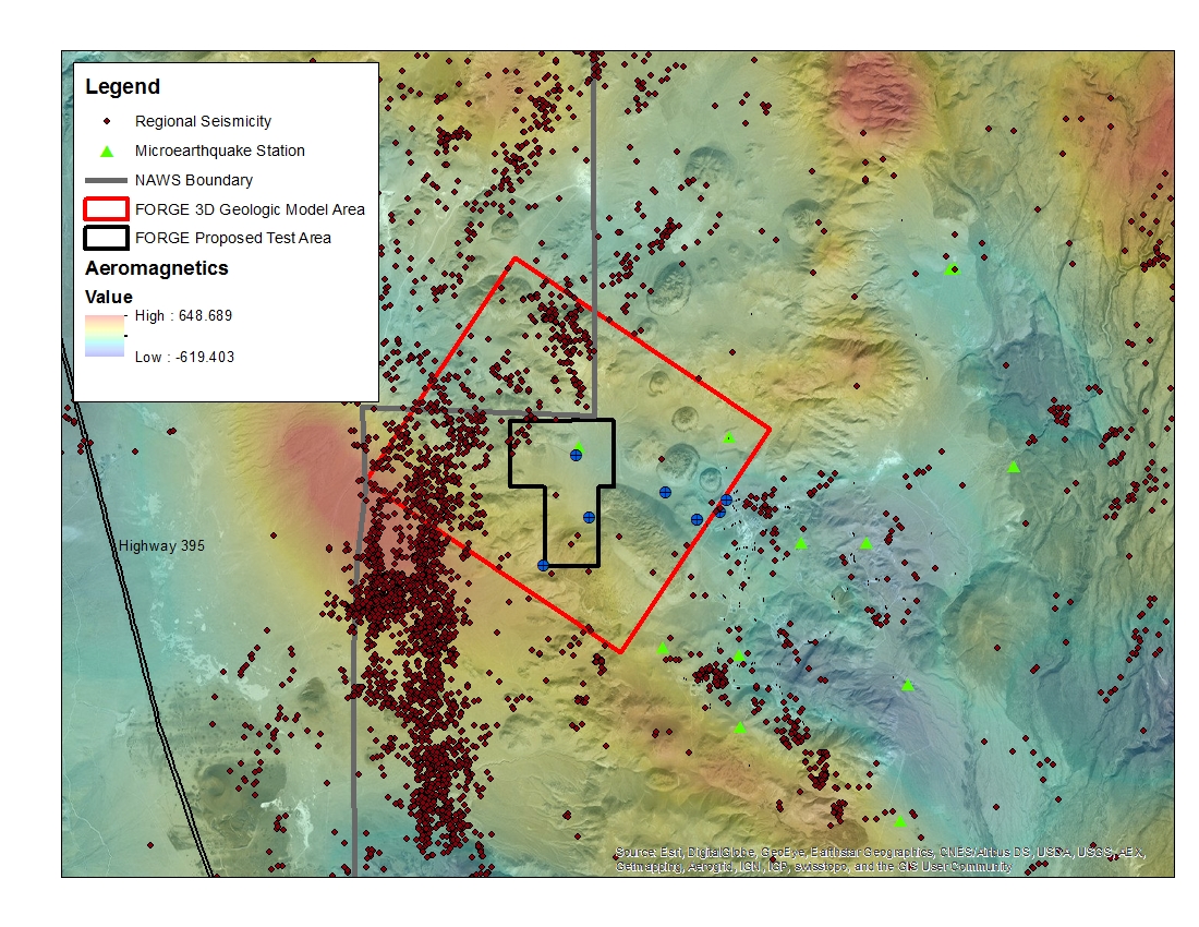
A map with the Coso West Flank FORGE test area outlined, along with regional seismicity, the aeromagnetic data set and the area currently being utilized for the creation of the 3D model.
Search relevance: 47.11 | Views last month: 0 -
Map, image, and data files, and a summary report of a high-resolution aeromagnetic survey of southern Maui, Hawai'i completed by EDCON-PRJ, Inc. for Ormat Nevada Inc using an helicopter and a...
Search relevance: 45.73 | Views last month: 0 -
Aeromagnetic data were collected along flight lines by instruments in an aircraft that recorded magnetic-field values and locations. In the earlier days of surveying, the only way to represent...
Search relevance: 45.24 | Views last month: 0 -
Aeromagnetic data were collected along flight lines by instruments in an aircraft that recorded magnetic-field values and locations. In the earlier days of surveying, the only way to represent...
Search relevance: 45.08 | Views last month: 0 -
Aeromagnetic data were collected along flight lines by instruments in an aircraft that recorded magnetic-field values and locations. In the earlier days of surveying, the only way to represent...
Search relevance: 44.71 | Views last month: 0 -
Aeromagnetic data were collected along flight lines by instruments in an aircraft that recorded magnetic-field values and locations. In the earlier days of surveying, the only way to represent...
Search relevance: 44.71 | Views last month: 0 -
Aeromagnetic data were collected along flight lines by instruments in an aircraft that recorded magnetic-field values and locations. In the earlier days of surveying, the only way to represent...
Search relevance: 44.42 | Views last month: 0 -
Aeromagnetic data were collected along flight lines by instruments in an aircraft that recorded magnetic-field values and locations. In the earlier days of surveying, the only way to represent...
Search relevance: 44.29 | Views last month: 0 -
Aeromagnetic data were collected along flight lines by instruments in an aircraft that recorded magnetic-field values and locations. In the earlier days of surveying, the only way to represent...
Search relevance: 44.29 | Views last month: 0 -
The U.S. Geological Survey (USGS) collected rock magnetic susceptibility measurements to help understand causative sources of airborne magnetic survey anomalies in the Iron Mountain-Menominee...
Search relevance: 42.64 | Views last month: 1 -
From February 12 to March 8, 1981, EG and G Geometrics conducted an aeromagnetic survey in Montana for Anaconda Copper Company. A Piper Navajo aircraft was used to conducted the survey. The survey...
Search relevance: 38.26 | Views last month: 3 -
The geology of Loudoun County, Virginia, was mapped in 1988 through 1991 under a cooperative agreement between the U.S. Geological Survey (USGS) and the Loudoun County Department of Environmental...
Search relevance: 36.47 | Views last month: 0 -
Regional geophysical data grid files provided in Grid eXchange File (GXF) format were used to study crustal architecture beneath the Southern Midcontinent (USA) by McCafferty and others (2019)....
Search relevance: 36.00 | Views last month: 0 -
This U.S. Geological Survey (USGS) data release provides a digital geospatial database for the reconnaissance geologic map of the Hells Canyon Study Area, Wallowa County, Oregon, and Idaho and...
Search relevance: 34.88 | Views last month: 1 -
This geologic map depicts and briefly describes geologic units underlying Petroglyph National Monument and immediately adjacent areas in Bernalillo County, New Mexico. The Monument is underlain...
Search relevance: 34.68 | Views last month: 0 -
A detailed airborne gravity gradiometry, magnetic, and radiometric survey of Mountain Pass, California was flown by CGG Canada Services Ltd. (CGG). The high-resolution helicopter survey was flown...
Search relevance: 34.62 | Views last month: 0
