
Found 113 datasets matching "Camas".
-
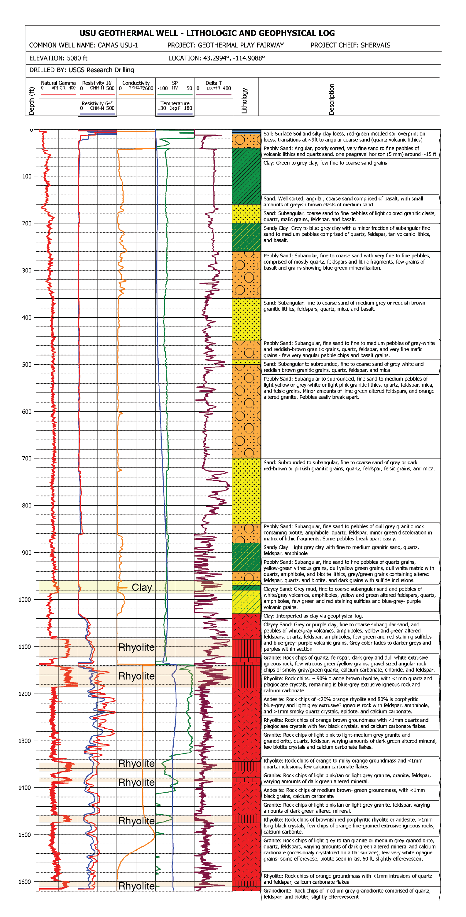
This submission contains documents that describe the USU Camas-1 test well, drilled in Camas Prairie, Idaho, in Fall 2018 and Fall 2019. The purpose of this well is to validate exploration...
Search relevance: 129.23 | Views last month: 0 -
Lead in Drinking Water in Schools Test Results – Camas Elementary School
Search relevance: 110.61 | Views last month: 1 -
Camas High School lead in drinking water test results
Search relevance: 110.50 | Views last month: 0 -
Lead in Drinking Water in Schools Test Results – Camas High School
Search relevance: 110.25 | Views last month: 0 -
Lead in Drinking Water in School test results - Camas Prairie Elementary Update Results
Search relevance: 104.53 | Views last month: 1 -
This dataset includes chemistry of geothermal water samples of the Camas Prairie area in Idaho. The samples included in this dataset were collected over the period of 2016-2019....
Search relevance: 103.21 | Views last month: 1 -
This dataset represents the LiDAR boundary for the Camas National Wildlife Refuge in Jefferson and Clark County, Idaho. This data is projected into Idaho State Plane East, U.S, Survey Feet The...
Search relevance: 97.73 | Views last month: 2 -
This dataset represents the Camas National Wildlife Refuge survey area in Jefferson and Clark County, ID. This bare earth digital elevation model (DEM) represent the earth's surface with all...
Search relevance: 81.46 | Views last month: 0 -
This geospatial dataset consists of points corresponding to the center of 50 x 50 m grid cells which were surveyed for a finite set of target invasive plant species on Camas National Wildlife...
Search relevance: 75.49 | Views last month: 0 -
This geodatabase includes 4 polygon-based feature classes representing different scales and levels of detail: 1) Full spatial detail, over 16,000 polygons mapped to Group and Alliance level....
Search relevance: 75.05 | Views last month: 0 -
USU Camas-1 is a geothermal test well drilled in Camas Prairie, Idaho, in the Summer and Fall of 2018. The purpose of this test well was to validate Play Fairway methodologies of the Snake River...
Search relevance: 74.69 | Views last month: 0 -
The TIGER/Line shapefiles and related database files (.dbf) are an extract of selected geographic and cartographic information from the U.S. Census Bureau's Master Address File / Topologically...
Search relevance: 72.19 | Views last month: 0 -
The TIGER/Line shapefiles and related database files (.dbf) are an extract of selected geographic and cartographic information from the U.S. Census Bureau's Master Address File / Topologically...
Search relevance: 72.19 | Views last month: 0 -
The TIGER/Line shapefiles and related database files (.dbf) are an extract of selected geographic and cartographic information from the U.S. Census Bureau's Master Address File / Topologically...
Search relevance: 71.01 | Views last month: 0 -
The TIGER/Line shapefiles and related database files (.dbf) are an extract of selected geographic and cartographic information from the U.S. Census Bureau's Master Address File / Topologically...
Search relevance: 70.91 | Views last month: 0 -
The TIGER/Line shapefiles and related database files (.dbf) are an extract of selected geographic and cartographic information from the U.S. Census Bureau's Master Address File / Topologically...
Search relevance: 70.61 | Views last month: 0 -
The TIGER/Line shapefiles and related database files (.dbf) are an extract of selected geographic and cartographic information from the U.S. Census Bureau's Master Address File / Topologically...
Search relevance: 70.33 | Views last month: 1 -
This resource is a member of a series. The TIGER/Line shapefiles and related database files (.dbf) are an extract of selected geographic and cartographic information from the U.S. Census Bureau's...
Search relevance: 70.17 | Views last month: 2 -
The TIGER/Line shapefiles and related database files (.dbf) are an extract of selected geographic and cartographic information from the U.S. Census Bureau's Master Address File / Topologically...
Search relevance: 68.99 | Views last month: 0 -
The TIGER/Line shapefiles and related database files (.dbf) are an extract of selected geographic and cartographic information from the U.S. Census Bureau's Master Address File / Topologically...
Search relevance: 68.94 | Views last month: 1
