
Found 13 datasets matching "Fort Bliss".
-
This dataset contains a variety of data about the Fort Bliss geothermal area, part of the southern portion of the Tularosa Basin, New Mexico. The dataset contains schematic models for the...
Search relevance: 220.87 | Views last month: 0 | Published on: 2026-01-27 -
This is a zipped file containing raw magnetotelluric (MT) data collected as part of the Phase 2 Tularosa Basin geothermal play fairway analysis project in New Mexico. The data for each MT station...
Search relevance: 185.23 | Views last month: 0 | Published on: 2026-01-27 -
Declining groundwater levels in the Hueco Bolson have raised concerns about the amount of available groundwater and the potential for water-quality changes. Fresh groundwater stored in the...
Search relevance: 109.19 | Views last month: 0 | Published on: 2026-03-03 -
Tularosa Basin Play Fairway Analysis: Modeled MT Resistivity Data for the McGregor Range, New Mexico
This is the inversion resistivity data from a magnetotelluric survey done as part of Phase 2 Tularosa Basin, New Mexico, geothermal play fairway analysis. The data covers part of McGregor Range,...
Search relevance: 104.36 | Views last month: 0 | Published on: 2026-01-27 -
The Transboundary Aquifer Assessment Act was established to systematically assess priority aquifers along the U.S.-Mexico international boundary. The priority aquifers that were specified include...
Search relevance: 94.18 | Views last month: 0 | Published on: 2026-03-03 -
This submission includes a geotiff of the geographic extent of Pleistocene Lake Otero; which was used as apart of the groundwater composite risk segment in a Tularosa Basin Play Fairway Analysis.
Search relevance: 40.48 | Views last month: 0 | Published on: 2026-01-27 -
NREL, as part of the Play Fairway Analysis (PFA) Retrospective and with assistance from PFA PIs, completed GeoRePORTs for the sites identified in Phases 1&2 of the DOE PFA projects. The GeoRePORT...
Search relevance: 40.28 | Views last month: 0 | Published on: 2026-01-27 -
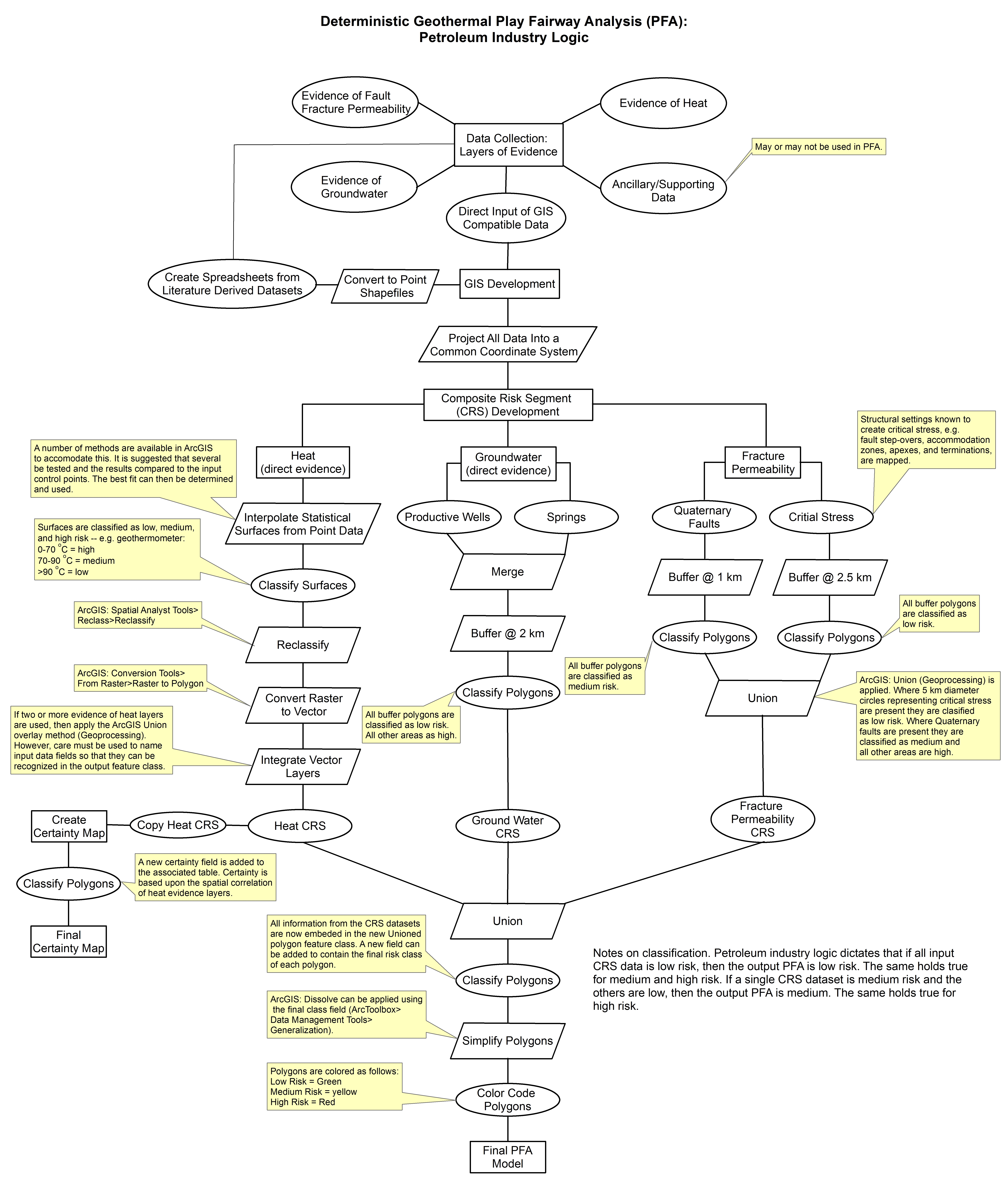
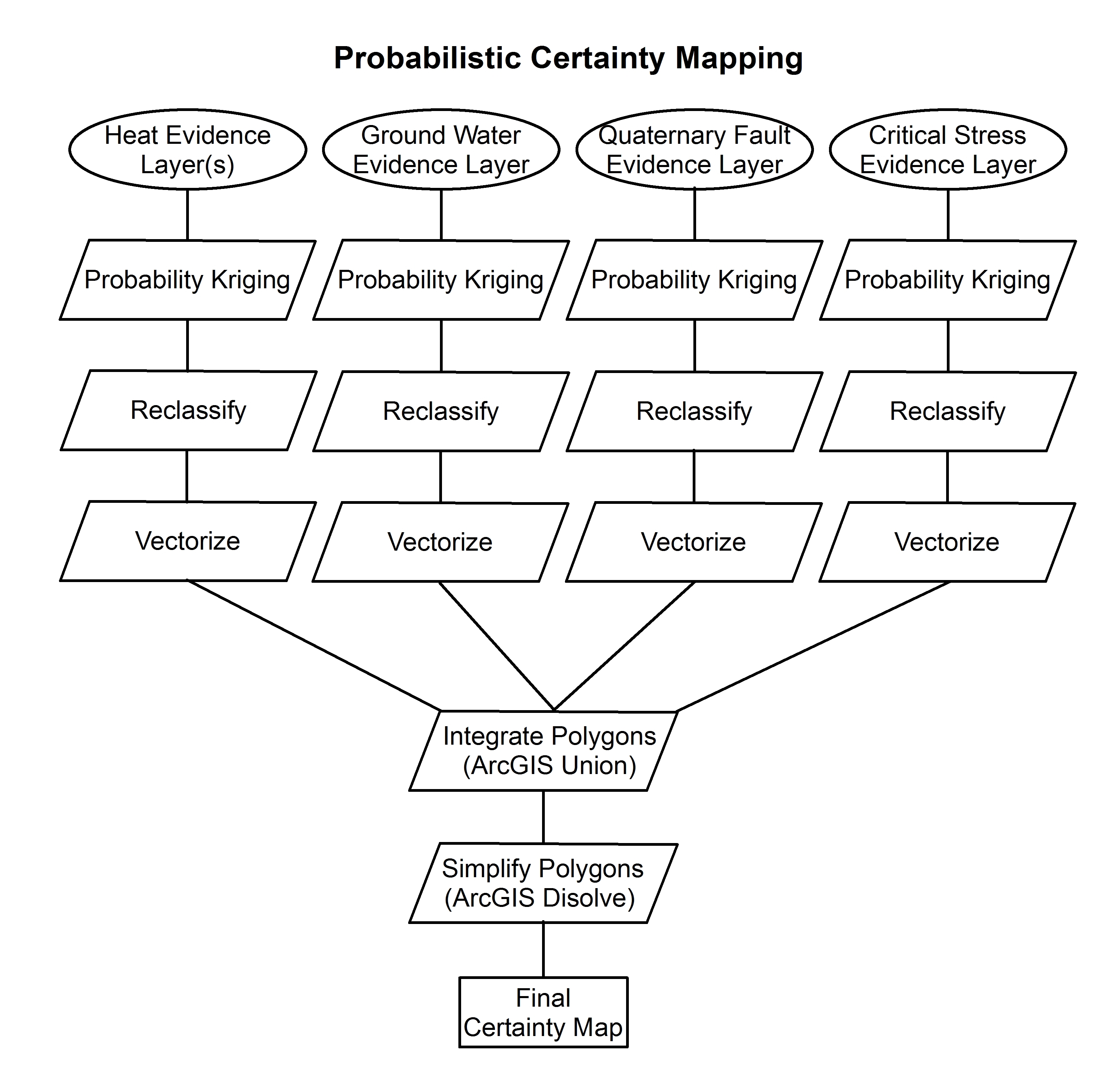
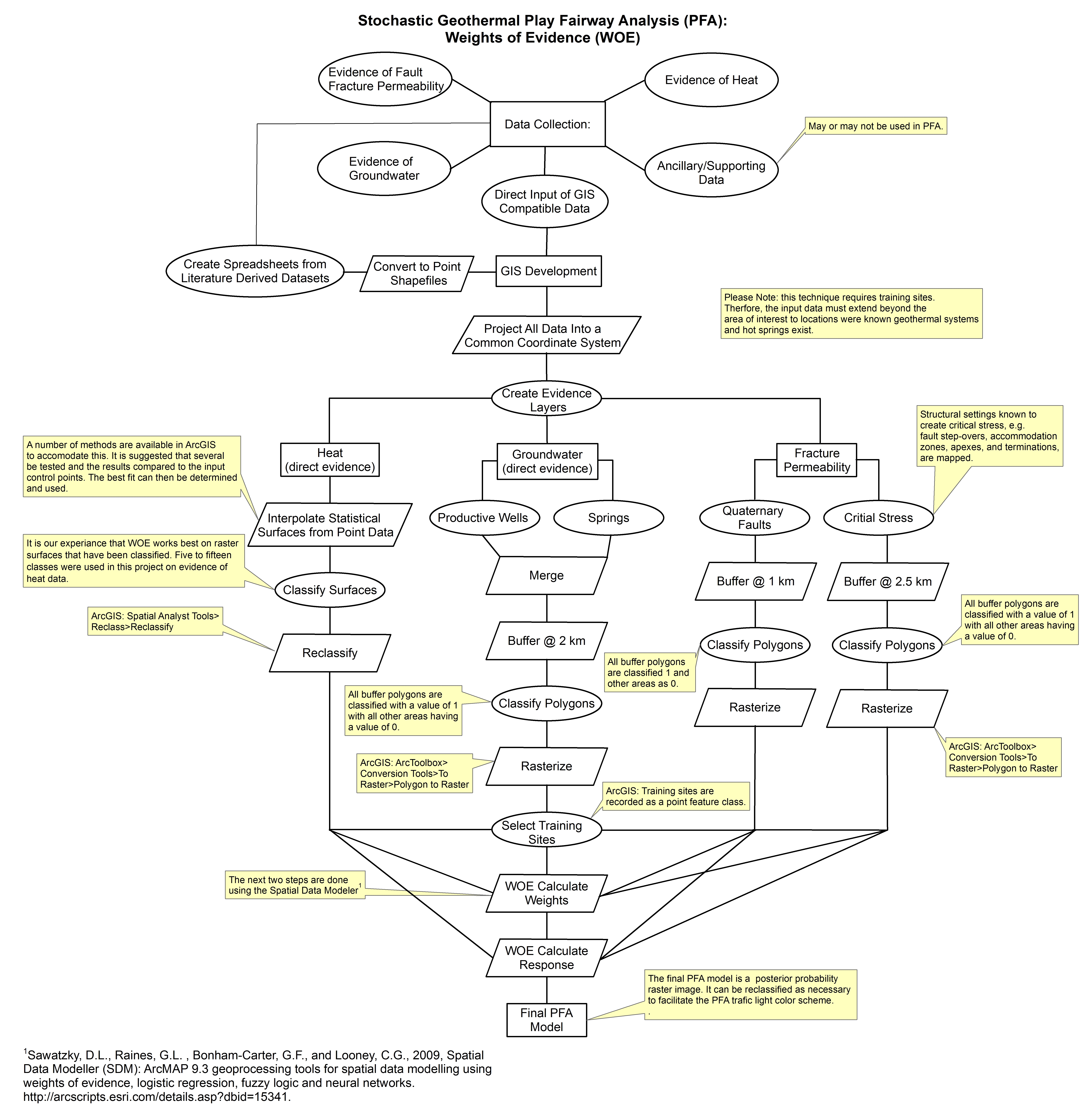
These images show the comprehensive methodology used for creation of a Play Fairway Analysis to explore the geothermal resource potential of the Tularosa Basin, New Mexico. The deterministic...
Search relevance: 39.95 | Views last month: 0 | Published on: 2026-01-27 -
This submission contains several shapefiles used for a deterministic PFA, as well as a heat composite risk segment with union overlay, and training sites used for weights of evidence. More...
Search relevance: 38.67 | Views last month: 0 | Published on: 2026-01-27 -
Tularosa Basin Play Fairway Analysis: Partial Basin and Range Heat and Zones of Critical Stress Maps
Interpolated maps of heat flow, temperature gradient, and quartz geothermometers are included as TIF files. Zones of critical stress map is also included as a TIF file. The zones are given a 5km...
Search relevance: 37.97 | Views last month: 0 | Published on: 2026-01-27 -
In this submission is the groundwater composite risk segment (CRS) used for play fairway analysis. Also included is a heat flow probability map, and a shaded relief map of the Tularosa Basin, NM.
Search relevance: 37.13 | Views last month: 0 | Published on: 2026-01-27 -
More than 87 percent of Crescent mule deer tracked for >100 days displayed clear migratory behavior, making this herd one of the more migratory herds in Oregon. Most mule deer winter close to...
Search relevance: 27.09 | Views last month: 2 | Published on: 2026-03-03 -
More than 87 percent of Crescent mule deer tracked for >100 days displayed clear migratory behavior, making this herd one of the more migratory herds in Oregon. Most mule deer winter close to...
Search relevance: 26.86 | Views last month: 1 | Published on: 2026-03-03
