
Found 15 datasets matching "Input-Output Accounts".
-
BEA's annual input-output (I-O) accounts provide a time series of detailed, consistent information on the flow of goods and services that make up the production processes of industries. The...
Search relevance: 307.15 | Views last month: 0 -
BEA's industry accounts are used extensively by policymakers and businesses to understand industry interactions, productivity trends, and the changing structure of the U.S. economy.
Search relevance: 89.78 | Views last month: 0 -
BEA has an updated interactive data application to make it easier to access and use our statistics. The application provides a common look and feel for users accessing national, international,...
Search relevance: 78.22 | Views last month: 0 -
-
The Transportation Satellite Accounts (TSAs) provide a means for measuring the contribution of transportation services to the national economy. Prior to the TSAs, the magnitude of transportation...
Search relevance: 62.00 | Views last month: 0 -
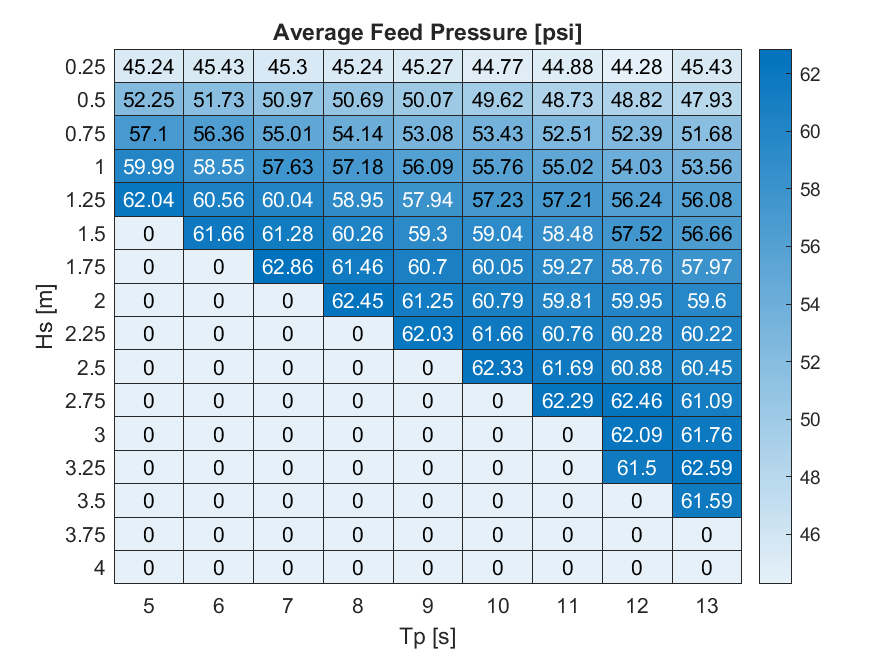
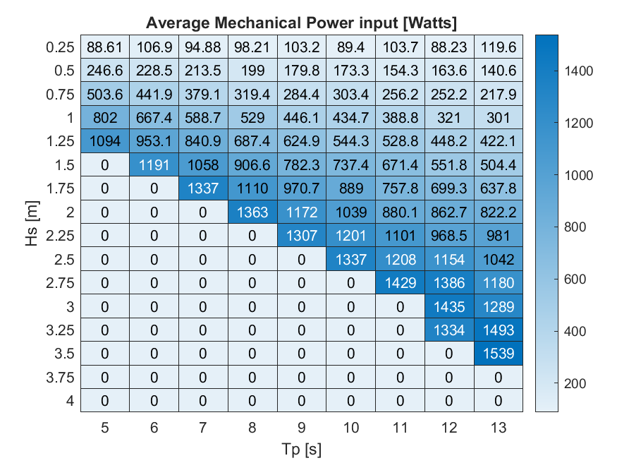
Data sets from simulation runs include 144 wave cases that were run based on the WEC-Sim model (https://mhkdr.openei.org/submissions/483). The 144 wave cases represent waves with the following...
Search relevance: 61.28 | Views last month: 0 -
The National Greenhouse Gas Industry Attribution Model is dynamic model that attributes US Greenhouse Gas (GHG) emissions as reported in the US GHG Inventory [1] to industry sectors as classified...
Search relevance: 60.40 | Views last month: 25 -
Generalized least squares (GLS) techniques were used with at-site statistics, from PeakFQ, and drainage area for streamgages in Puerto Rico to calculate regional regression equations for ungaged...
Search relevance: 45.64 | Views last month: 1 -
A three-dimensional groundwater flow model (MODFLOW200-FMP1_1) of the Central Valley in California was developed to aid water managers in understanding how water moves through the aquifer...
Search relevance: 38.22 | Views last month: 0 -
A generalized least squares (GLS) technique was used with at-site n-day low-flow time series and frequencies, from SWToolbox (Kiang and others, 2018), and 14 basin characteristics (basin...
Search relevance: 37.89 | Views last month: 0 -
A three-dimensional groundwater flow model of the Central Valley in California was developed to aid water managers in understanding how water moves through the aquifer system, to predict...
Search relevance: 35.26 | Views last month: 0 -
A three-dimensional groundwater flow model using MODFLOW 6 (version 6.2.2) was developed and calibrated for unconsolidated Coastal Plain aquifers underlying the Joint Base McGuire-Dix-Lakehurst...
Search relevance: 33.77 | Views last month: 0 -
A reach of the North Santiam River, Oregon, was used as a case study in an ongoing effort to develop and test uncrewed aircraft system (UAS)-based salmon habitat mapping techniques using: (1)...
Search relevance: 21.32 | Views last month: 0 -
Gap Analysis Project (GAP) habitat maps are predictions of the spatial distribution of suitable environmental and land cover conditions within the United States for individual species. Mapped...
Search relevance: 16.70 | Views last month: 0
