
Found 54 datasets matching "Petroleum Exploration".
-
National Petroleum Reserve-Alaska (NPRA) Legacy Data Archive: 1944-1982 Exploration and Seismic Data
The National Petroleum Reserve-Alaska (NPRA) Legacy Data Archive contains geological and geophysical data collected during two extensive exploration programs, operated first by the U.S. Navy...
Search relevance: 121.38 | Views last month: 9 -
Wells drilled during oil and gas exploration use drilling fluids to cool and lubricate the drilling bit and clear the borehole of cuttings. These fluids are recycled during the drilling process,...
Search relevance: 79.50 | Views last month: 0 -
Cell maps are created by the USGS as a method for illustrating the degree of petroleum exploration, type of production as indicated by final well status, distribution of production and well...
Search relevance: 72.39 | Views last month: 0 -
This shapefile includes polygons that describe U.S. Geological Survey delineated Total Petroleum Systems of northern Afghanistan. Each petroleum system is defined as a mappable entity encompassing...
Search relevance: 59.26 | Views last month: 0 -
Compilation of Geospatial Data (GIS) for the Mineral Industries and Related Infrastructure of Africa
This geodatabase reflects the U.S. Geological Survey’s (USGS) ongoing commitment to its mission of understanding the nature and distribution of global mineral commodity supply chains by updating...
Search relevance: 58.98 | Views last month: 0 -
This shapefile includes arcs and polygons that describe U.S. Geological Survey defined 33 geologic provinces of the Circum-Arctic (north of the Arctic Circle). Each province has a set of geologic...
Search relevance: 57.26 | Views last month: 2 -
This shapefile includes arcs and polygons that describe U.S. Geological Survey delineated Total Petroleum Systems of the World. Each petroleum system is defined as a mappable entity encompassing...
Search relevance: 57.08 | Views last month: 4 -
The boundaries illustrated by these Assessment Units are the result of geologic studies conducted by the World Petroleum Resources Project, 2009-2011 (Project). The boundaries were used to assess...
Search relevance: 55.79 | Views last month: 0 -
This shapefile includes polygons and regions that describe U.S. Geological Survey defined petroleum resource Assessment Units of northern Afghanistan. Each assessment unit is defined as a mapable...
Search relevance: 55.21 | Views last month: 0 -
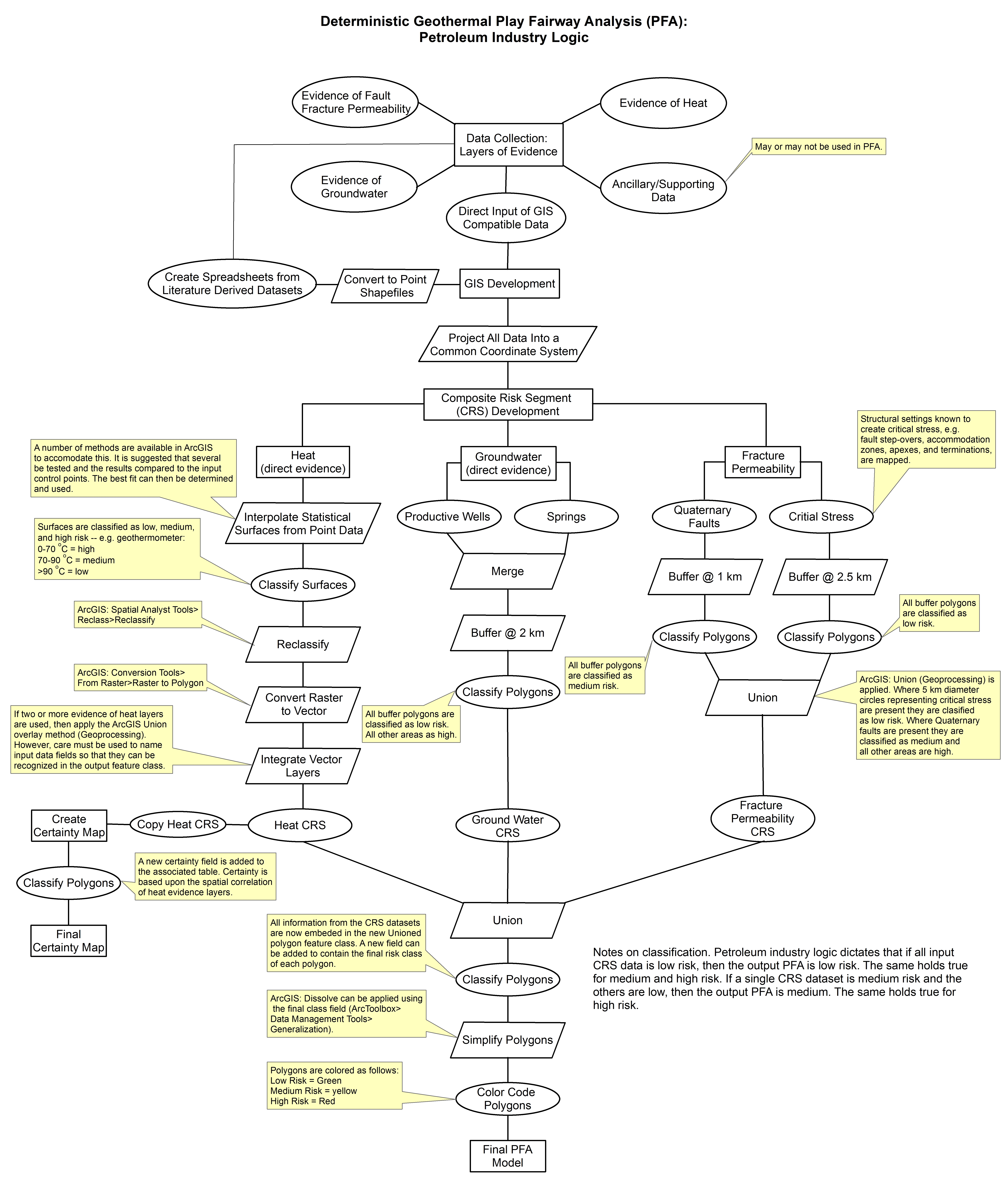
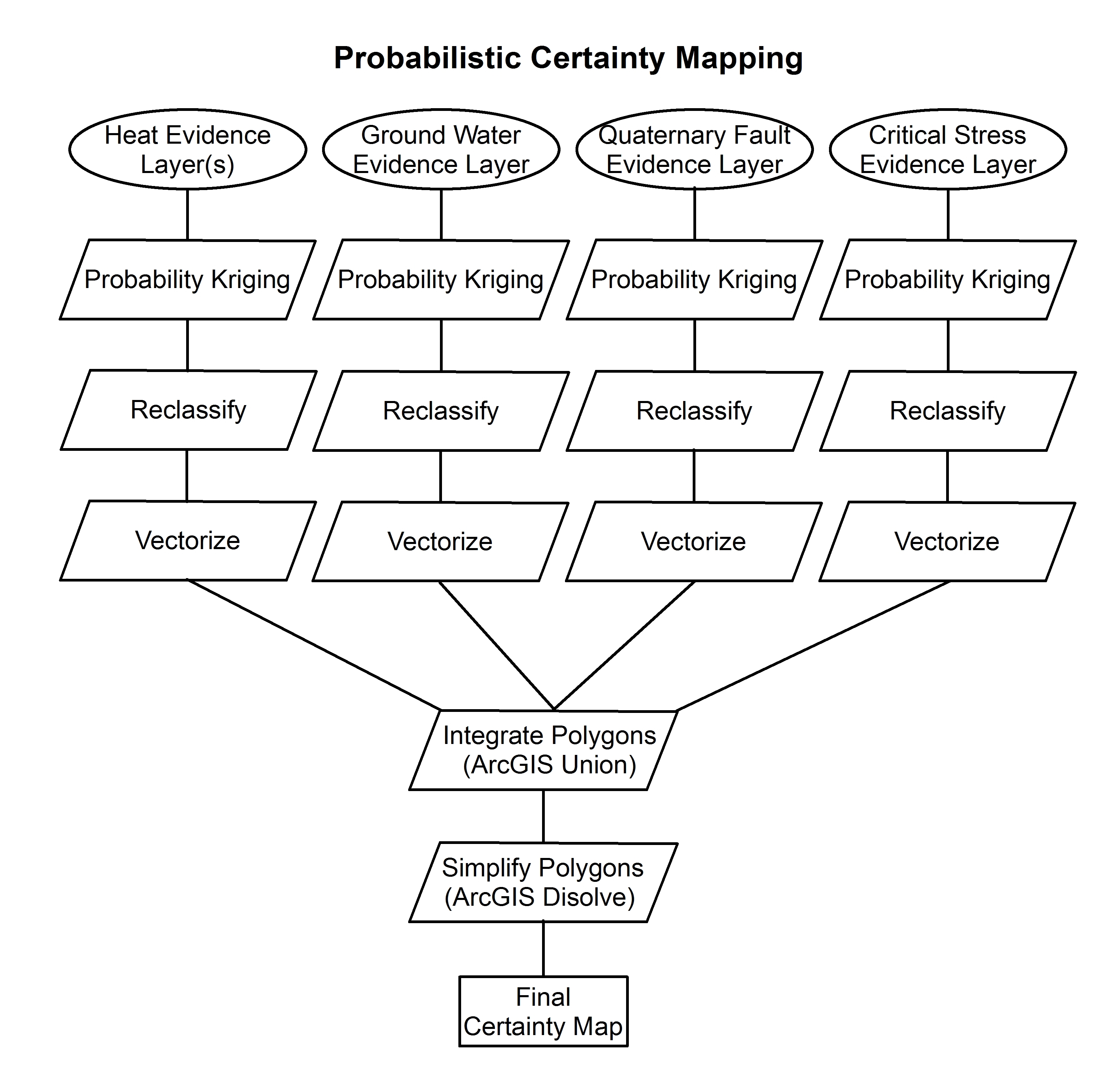
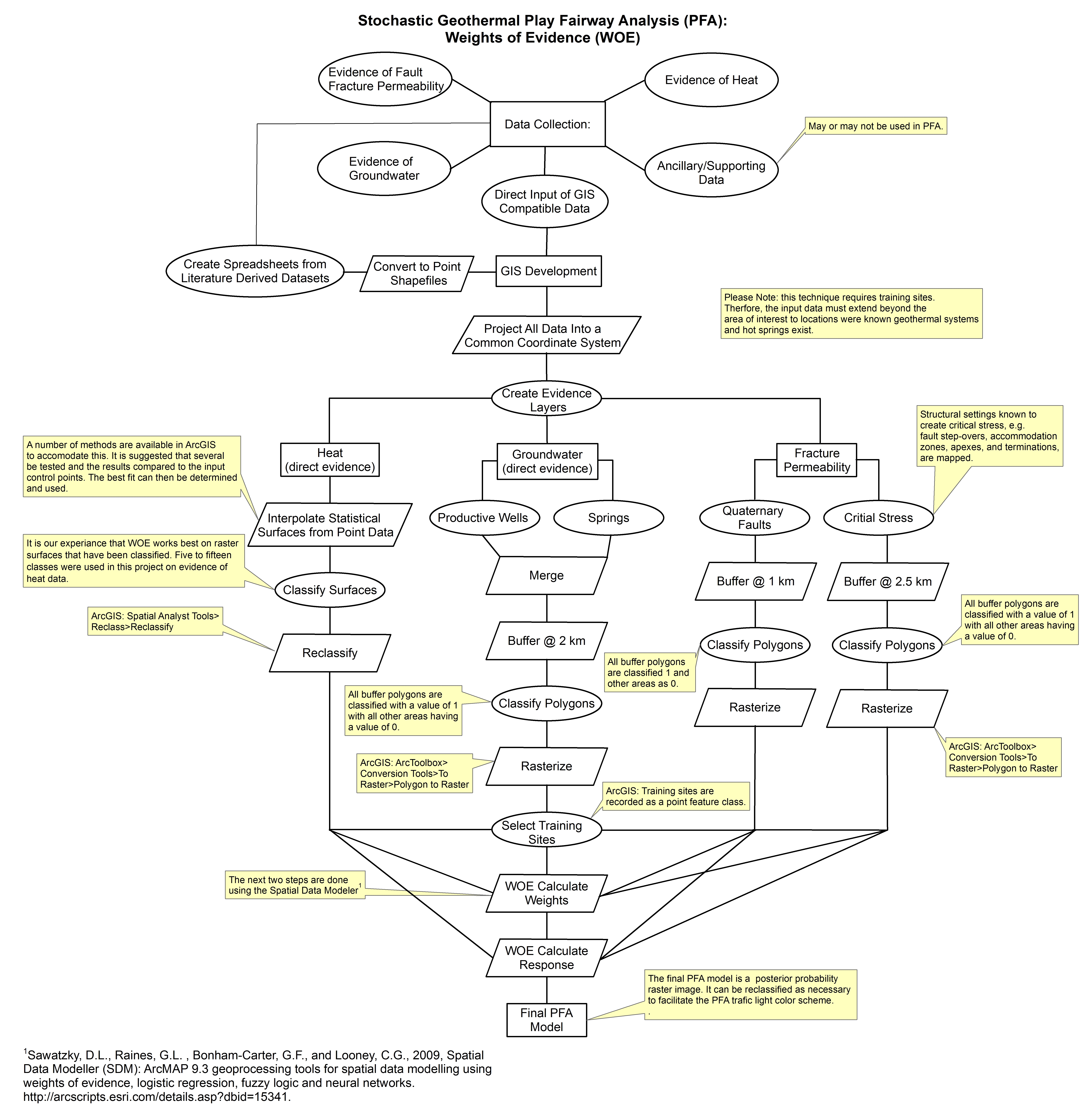
These images show the comprehensive methodology used for creation of a Play Fairway Analysis to explore the geothermal resource potential of the Tularosa Basin, New Mexico. The deterministic...
Search relevance: 53.77 | Views last month: 0 -
This shapefile includes arcs and polygons that describe U.S. Geological Survey defined geologic provinces of the World. Each province has a set of geologic characteristics distinguishing it from...
Search relevance: 53.47 | Views last month: 2 -
This shapefile includes arcs and polygons that describe U.S. Geological Survey defined geologic provinces of the World. Each province has a set of geologic characteristics distinguishing it from...
Search relevance: 53.24 | Views last month: 2 -
This coverage includes arcs, polygons and polygon labels that describe U.S. Geological Survey defined geologic provinces of the Africa. Each province has a set of geologic characteristics...
Search relevance: 52.97 | Views last month: 0 -
This shapfile includes arcs and polygons that describe U.S. Geological Survey defined petroleum resource Assessment Units of the World. Each assessment unit is defined as a mappable volume of...
Search relevance: 52.51 | Views last month: 3 -
This document describes a legacy collection of 2,263 scanned well logs from 621 distinct wells in the Piceance Basin of western Colorado, now made publicly available for long-term preservation....
Search relevance: 50.80 | Views last month: 0 -
This coverage includes arcs, polygons and polygon labels that describe U.S. Geological Survey defined geologic provinces of Europe including Turkey. (Albania, Andorra, Austria, Belgium, Bosnia and...
Search relevance: 49.20 | Views last month: 0 -
Shallow (300 ft or less) coal exploration drill-hole data from 692 wells located in Arkansas are provided in this data release. The well locations extend over nine Arkansas counties and were...
Search relevance: 47.44 | Views last month: 1 -
Submarine Exploration and Evaluation of Petroleum Seeps (SEEPS) (AT26-06, EM122). 1. Conduct in-situ incubations with devices for microbial growth, deployed in 2011. 2. Investigate the fate of...
Search relevance: 46.44 | Views last month: 0 -
This dataset comprises a collection of tabular data and graphical images supporting the U.S. Geological Survey's World Petroleum Assessment, extracted from USGS DDS 60 publication. The dataset...
Search relevance: 43.68 | Views last month: 0 -
This presents the results of Phase 1 of the Snake River Plain Play Fairway Analysis project, along with a proposed work for Phase 2. No new data were collected, but we list data sources for our...
Search relevance: 42.47 | Views last month: 0
