
Found 15 datasets matching "clay-rich".
-
Stratigraphic, geochemical, and hydrologic data for the Boston Peak wetland, Larimer County, CO, USA
Comprehensive sampling of peat, underlying lakebed sediments, and coexisting waters of a naturally uraniferous montane wetland are combined with hydrologic measurements to define the important...
Search relevance: 55.30 | Views last month: 1 -
This work investigates the characterization of bituminite (amorphous sedimentary organic matter) in Kimmeridge Clay source rock via confocal laser canning microscopy (CLSM) and atomic force...
Search relevance: 51.34 | Views last month: 0 -
Chemostratigraphic signatures were recorded in a 113 m thick outcrop of late Albian to early Campanian (~103–82 Ma) Hue Shale exposed on the bank of the Jago River in the coastal plain (“1002...
Search relevance: 49.44 | Views last month: 0 -
Mean random vitrinite reflectance (Ro) is the most widely accepted method to determine thermal maturity of coal and other sedimentary rocks. However, oil-immersion Ro of polished rock or kerogen...
Search relevance: 48.72 | Views last month: 0 -
The U.S. Geological Survey assessed undiscovered unconventional hydrocarbon resources reservoired in the Upper Cretaceous Tuscaloosa marine shale (TMS) of southern Mississippi and adjacent...
Search relevance: 37.47 | Views last month: 0 -
Mount Adams, also known by the Native American names "Klickitat" or "Pahto", is a 3,742 meter-tall (12,278 feet) stratovolcano located 53 km (33 miles) north of the Columbia river straddling the...
Search relevance: 30.18 | Views last month: 0 -
Enhanced reservoir connectivity generally requires maximizing the intersection between hydraulic fracture (HF) and preexisting underground natural fractures (NF), while having the hydraulic...
Search relevance: 28.07 | Views last month: 1 -
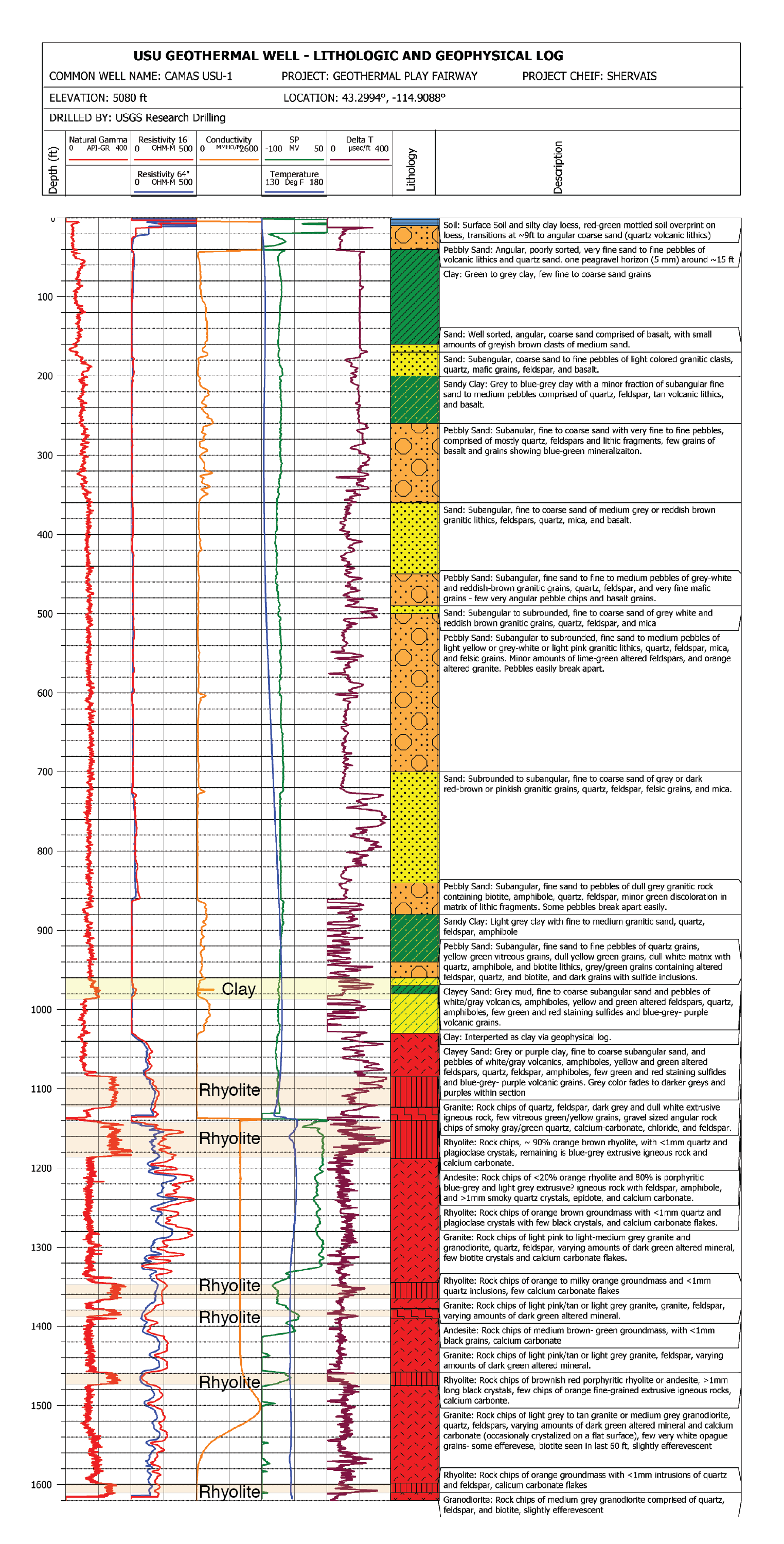
This submission contains documents that describe the USU Camas-1 test well, drilled in Camas Prairie, Idaho, in Fall 2018 and Fall 2019. The purpose of this well is to validate exploration...
Search relevance: 26.36 | Views last month: 0 -
This dataset is a polygon coverage of counties limited to the extent of the Pond Creek coal bed resource areas and attributed with statistics on the thickness of the Pond Creek coal zone, its...
Search relevance: 14.15 | Views last month: 0 -
This dataset is a polygon coverage of counties limited to the extent of the Pond Creek coal zone resource areas and attributed with remaining resources (millions of short tons) in aggregated...
Search relevance: 14.11 | Views last month: 0 -
This dataset is a polygon coverage of counties limited to the extent of the Pond Creek coal bed resource areas. Resource areas are only a subset of the entire areal extent of the Pond Creek coal...
Search relevance: 13.94 | Views last month: 0 -
This dataset is a point coverage of attributes on data location, thickness of the Pond Creek coal bed main bench, and its elevation, in feet. The file is also found as an ASCII Appendix of Chapter...
Search relevance: 13.94 | Views last month: 0 -
This dataset is a polygon coverage of counties limited to the extent of the Pond Creek coal zone resource areas and attributed with original resources (millions of short tons) in aggregated...
Search relevance: 13.83 | Views last month: 1 -
This dataset is a polygon coverage of counties limited to the extent of the Pond Creek coal zone resource areas and attributed with statistics on these coal quality parameters: ash yield...
Search relevance: 12.98 | Views last month: 0 -
This data release compiles major and trace element analytical results of samples of bauxite (aluminum ore) and associated rocks collected from the Arkansas bauxite region, located near the center...
Search relevance: 11.16 | Views last month: 3
