
Found 29 datasets matching "dump".
-
This dataset is a dump file from the PostgreSQL database of all of the marine biogeographic records available from the Ocean Biogeographic Information System (OBIS) USA as of 2015-01-16. NCEI...
Search relevance: 44.01 | Views last month: 0 -
The Data Layers include the following.Flooding: Regions that flood during heavy rainfall.Intermittent Streams: Areas flow as streams during heavy rainfall.Community drinking Water Sources:...
Search relevance: 42.51 | Views last month: 0 -
This is a dump file of the NaKnowBase - an SQL based relational database containing curated data from EPA's Office of Research and Development related to the environmental effects of engineered...
Search relevance: 39.54 | Views last month: 1 -
The Permian Basin, straddling New Mexico and Texas, is one of the most productive oil and gas (OG) provinces in the United States. OG production yields large volumes of wastewater that contain...
Search relevance: 36.60 | Views last month: 1 -
The sea surface temperature data in this accession was collected in Sea of Japan. Data in this accession was collected over a six month period from thermistor. The data was collected between...
Search relevance: 36.43 | Views last month: 0 -
The GINGAMODE database table contains selected information from the Large Area Counter (LAC) aboard the third Japanese X-ray astronomy satellite Ginga. The Ginga experiment began on day 36, 5...
Search relevance: 33.26 | Views last month: 0 -
This polyline data set contains the locations of oil and gas pipelines in the Gulf of America Outer Continental Shelf federal waters that are associated with the oil and gas industry's pipeline...
Search relevance: 31.04 | Views last month: 3 -
L1_cation.txt is a text dump of CEC data from EPIC output for the 12 km CMAQ grid for each of 42 crop types CMAQv53_bidi_fix_NH3_290871_scatterplot.csv is data table used for scatter plot of...
Search relevance: 30.88 | Views last month: 2 -
This layer represents the buffered geography around the known landfills in and around the City of Austin, Texas. Due to the uncertainty of the boundaries of the landfills; the buffers are used to...
Search relevance: 30.26 | Views last month: 0 -
This data set contains surface locations for oil and gas wells located in the Gulf of Mexico federal waters. Note: Wells are being added or modified continuously; obtaining updates of this...
Search relevance: 29.86 | Views last month: 12 -
This data set defines both current and historic landfills/waste disposal storage sites for the State of Vermont. Historic landfills were identified with the publication of the Vermont Ground Water...
Search relevance: 29.82 | Views last month: 0 -
This data set contains surface locations for oil and gas wells located in the Pacific Coast federal waters. Note: Wells are being added or modified continuously; obtaining updates of this...
Search relevance: 28.64 | Views last month: 15 -
This data set contains point locations for oil and gas platforms (structures) located in the Gulf of America federal waters. Note: Platforms are being added or modified continuously; obtaining...
Search relevance: 28.19 | Views last month: 5 -
The parsers featured in this module are constructed to parse LAMMPS output files, (i.e., dump files), containing data for given potential energy values (an approximation of the Hamiltonian),...
Search relevance: 28.16 | Views last month: 0 -
The parsers featured in this module are constructed to parse LAMMPS output files, (i.e., dump files), containing data for given potential energy values (an approximation of the Hamiltonian),...
Search relevance: 27.43 | Views last month: 0 -
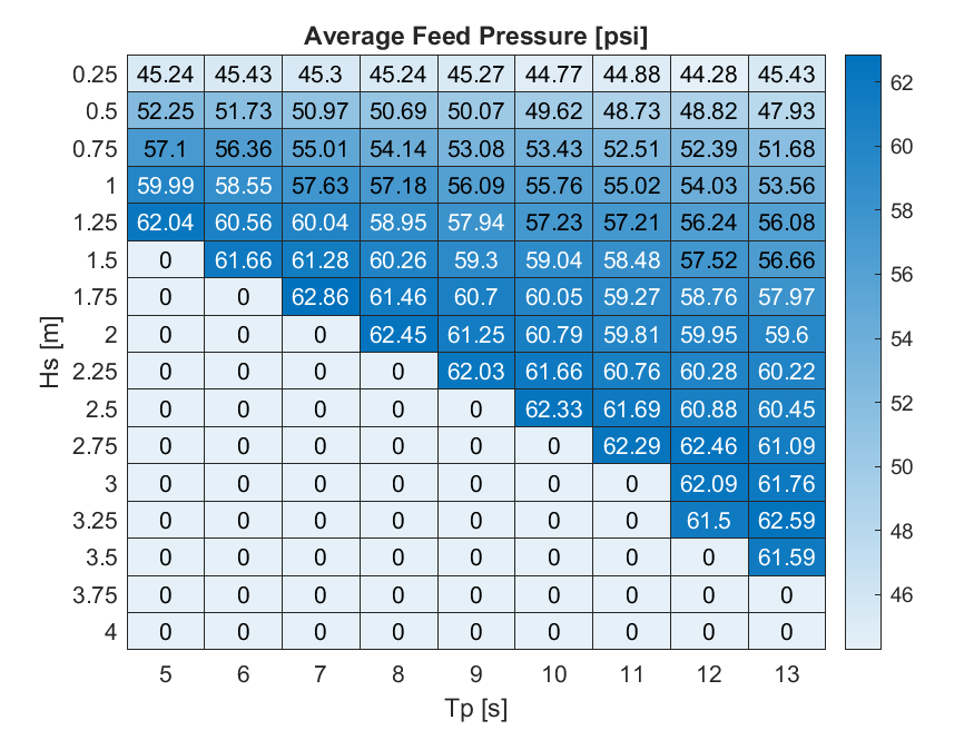
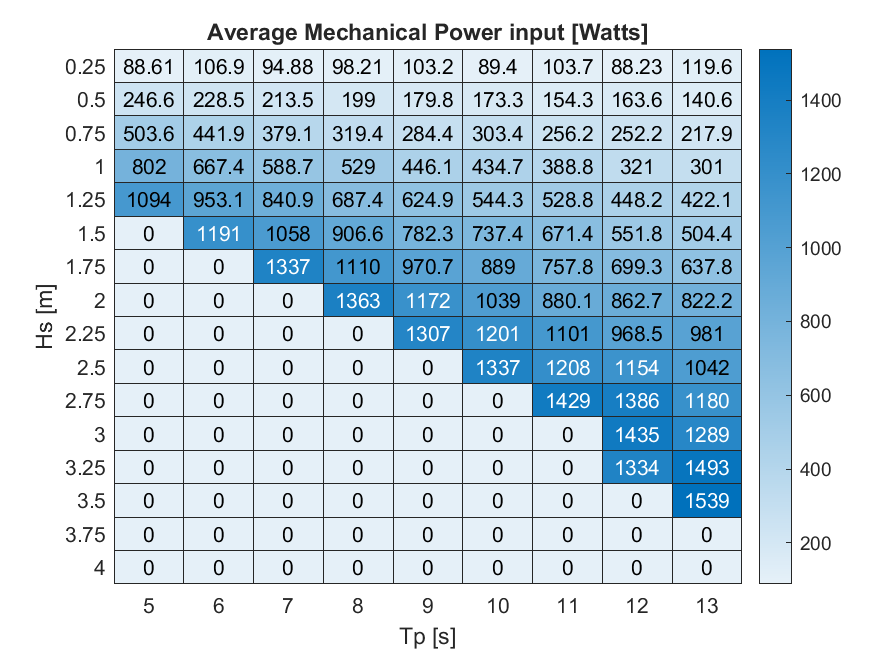
Data sets from simulation runs include 144 wave cases that were run based on the WEC-Sim model (https://mhkdr.openei.org/submissions/483). The 144 wave cases represent waves with the following...
Search relevance: 26.77 | Views last month: 0 -
A GPS receiver uses the energy of the L1 and L2 GPS satellite signals to track the phase of the L1 and L2 P-code and the carrier phase of the L2 signal. The in-phase channel of the L1 signal,...
Search relevance: 25.54 | Views last month: 0 -
This collection contains cruises beginning in 1985 and continuing up to the present, which were received, reviewed, and prepared for archival at the Joint Archive (JA) for Shipboard Acoustic...
Search relevance: 24.99 | Views last month: 0 -
The GINGALOG database table contains selected information from the Large Area Counter (LAC) aboard the third Japanese X-ray astronomy satellite Ginga. The Ginga experiment began on day 36, 5...
Search relevance: 24.02 | Views last month: 1 -
The National Oceanic and Atmospheric Administration (NOAA) has the statutory mandate to collect hydrographic data in support of nautical chart compilation for safe navigation and to provide...
Search relevance: 23.86 | Views last month: 0
