
Found 15 datasets matching "flow chart".
-
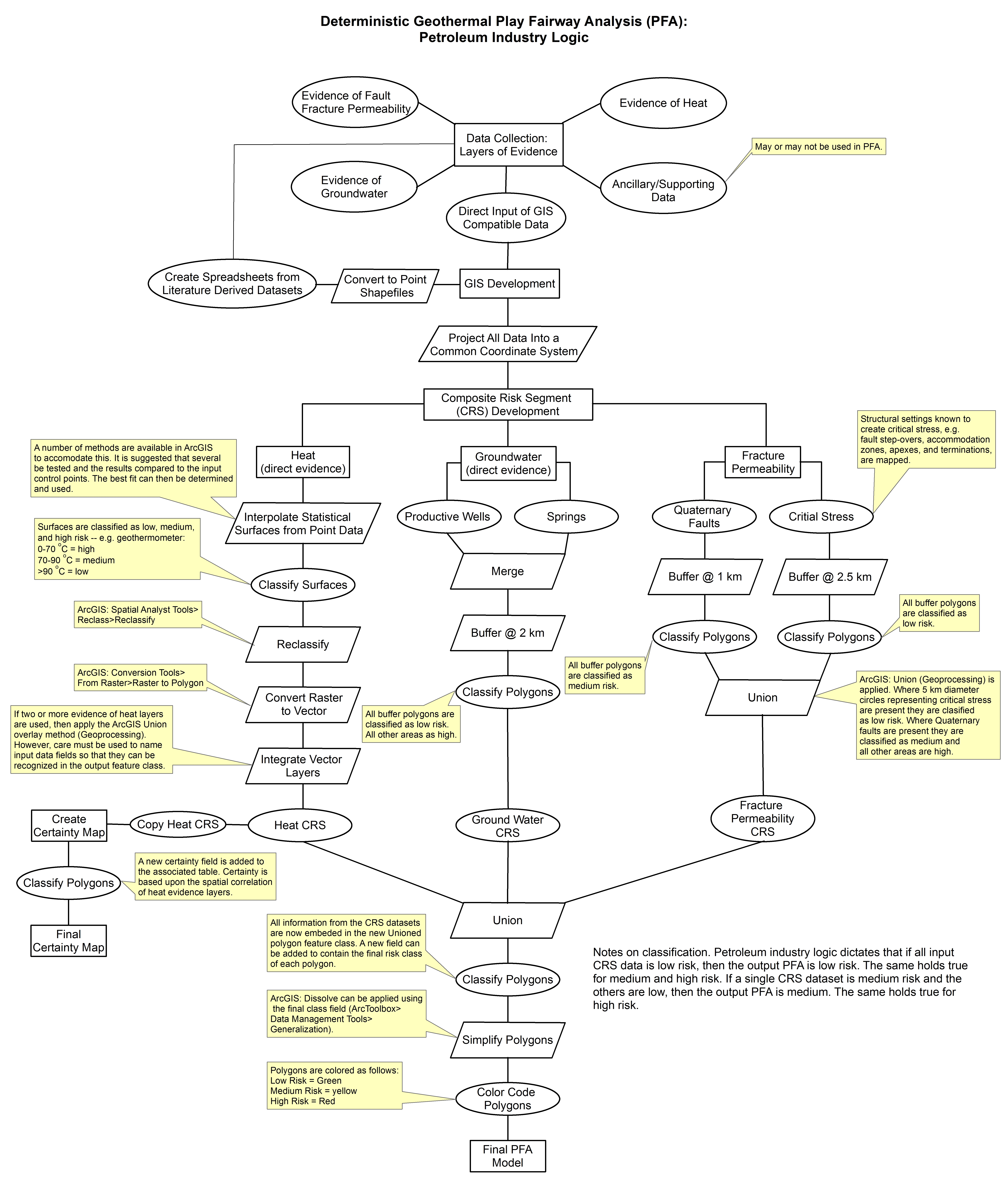
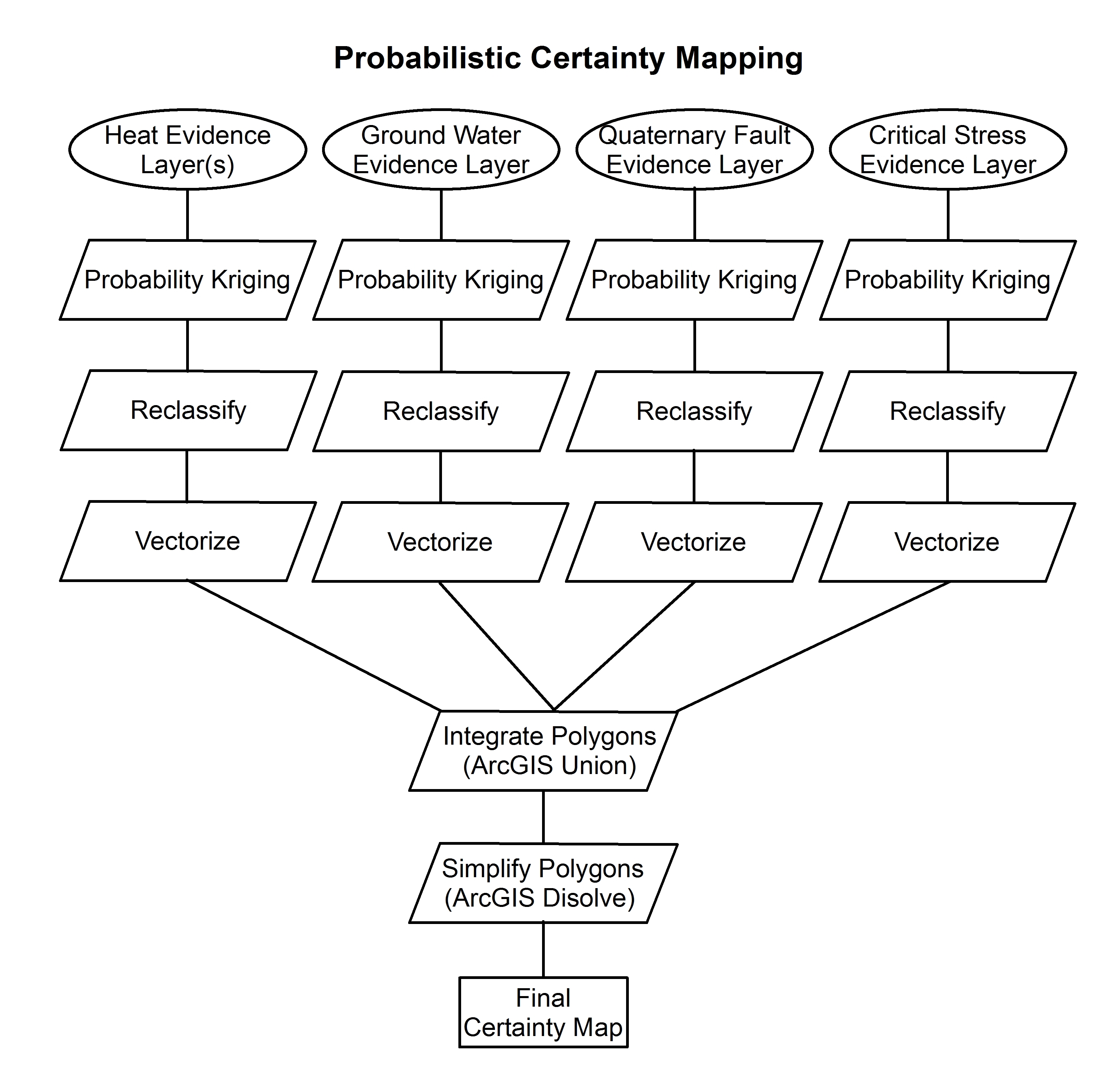
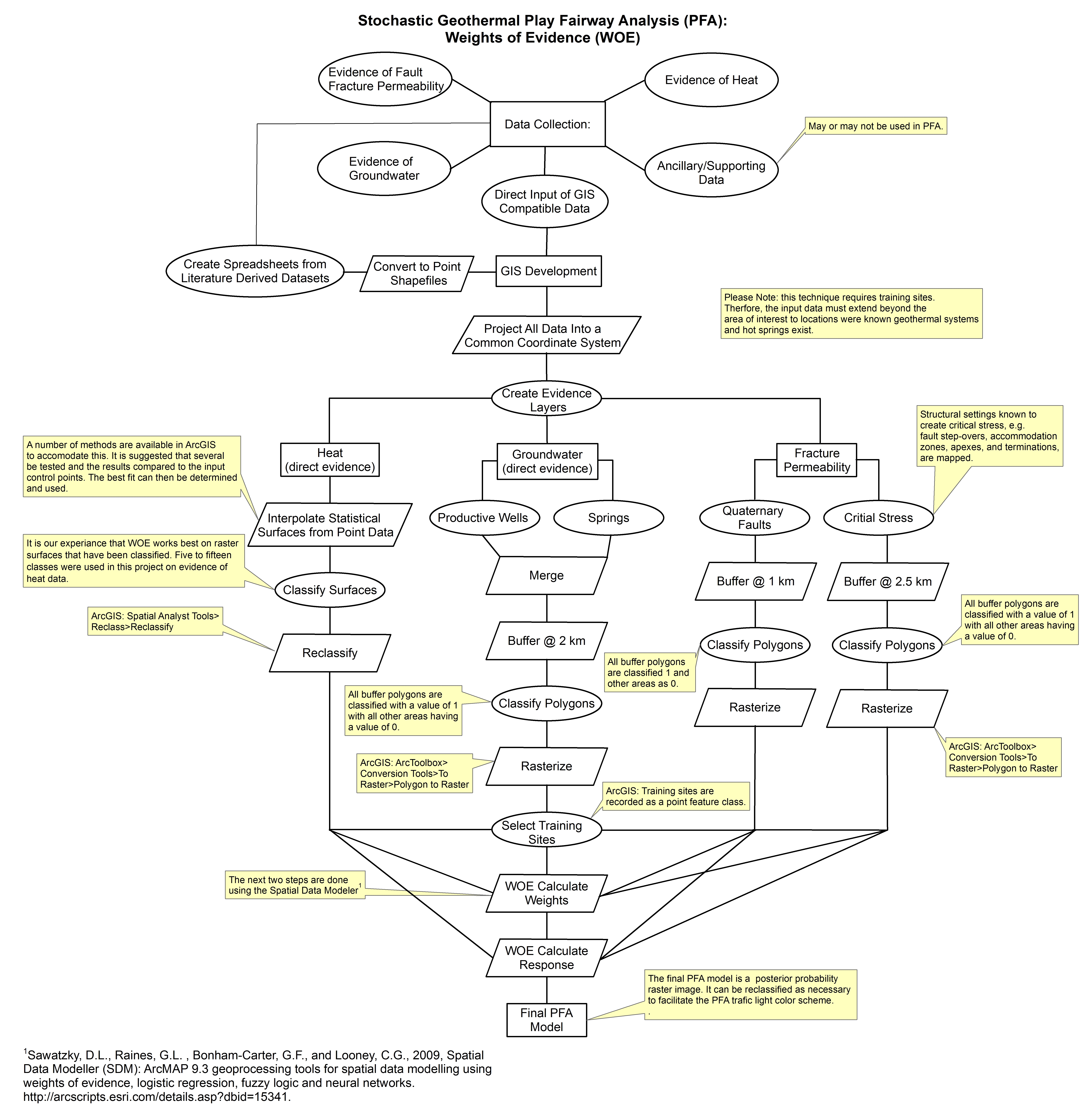
These images show the comprehensive methodology used for creation of a Play Fairway Analysis to explore the geothermal resource potential of the Tularosa Basin, New Mexico. The deterministic...
Search relevance: 73.17 | Views last month: 0 -
This archive contains data from the tracer test performed during the Utah FORGE well 16A(78)-32 stimulation. This includes: 1. the raw data file from Pason in the csv format; 2. a one-page Word...
Search relevance: 30.58 | Views last month: 0 -
This data set provides high-resolution (~500 m) gridded land and stream drainage direction maps for the Amazon River basin, excluding the Rio Tocantins basin. These maps are the result of a new...
Search relevance: 28.15 | Views last month: 0 -
There are 3 data sets. Two zip files contain paired biological (benthic macroinvertebrate genera) (Data Biological.zip) and water quality data (Data Environmental.zip). These were used to...
Search relevance: 27.73 | Views last month: 0 -
Introduction Prone positioning in respiratory failure has been shown to be a useful adjunct in the treatment of severe hypoxia. However, the prone position can result in dislodgment or...
Search relevance: 26.27 | Views last month: 0 -
Background: The purpose of this study was to evaluate the effect of altering the use of the protocol for brain death determination in traumatically injured patients, on time to brain...
Search relevance: 24.72 | Views last month: 1 -
The Newberry Volcano EGS Demonstration in central Oregon, a 5 year project begun in 2010, tests recent technological advances designed to reduce the cost of power generated by EGS in a hot, dry...
Search relevance: 24.36 | Views last month: 0 -
Reynolds Creek Experimental Watershed discharge records are available for 13 stations with varying lengths of record ranging from 8 to 34 years. The U.S. Department of Agriculture, Agricultural...
Search relevance: 23.49 | Views last month: 5 -
A radar water level sensor (Campbell Scientific ® CS475A-L) was installed on the water intake tower of Lake Carl Blackwell, Payne County, Oklahoma (36.1351 N, 97.2195 W) to automate monitoring of...
Search relevance: 21.47 | Views last month: 18 -
Automated Sigma pump samplers were used at all RCEW gauging stations to collect instantaneous point measures of suspended-sediment concentration. The US Department of Agriculture, Agricultural...
Search relevance: 16.56 | Views last month: 2 -
Information on water depth in river channels is important for a number of applications in water resource management but can be difficult to obtain via conventional field methods, particularly over...
Search relevance: 12.53 | Views last month: 0 -
Information on water depth in river channels is important for a number of applications in water resource management but can be difficult to obtain via conventional field methods, particularly over...
Search relevance: 12.51 | Views last month: 0 -
Information on water depth in river channels is important for a number of applications in water resource management but can be difficult to obtain via conventional field methods, particularly over...
Search relevance: 11.91 | Views last month: 0 -
The Savannah Harbor Expansion Project (SHEP) began in January 2015 with the purpose of deepening the Savannah Harbor federal shipping channel to allow access to larger shipping vessels (U.S. Army...
Search relevance: 7.72 | Views last month: 0 -
Wastewater collection areas are comprised of merged sewage drainage basins that flow to a shared testing location for the COVID-19 wastewater study. The collection area polygons are published with...
Search relevance: 7.10 | Views last month: 1
