
Found 20 datasets matching "seismicity map".
-
This is a link to the Utah Geological Survey's Utah FORGE Interactive Geoscience Map. The map layers include information on geology, geography, subsurface temperatures, seismicity, gravity and...
Search relevance: 82.68 | Views last month: 0 -
ArcGIS Map Package with MT Station Locations, 2D Seismic Lines, Well data, Known Regional Hydrothermal Systems, Regional Historic Earthquake Seismicity, Regional Temperature Gradient Data,...
Search relevance: 72.53 | Views last month: 0 -
This submission contains information used to compute the combined risk factors for deep geothermal energy opportunities in the Appalachian Basin, in the context of a the Play Fairway Analysis...
Search relevance: 61.62 | Views last month: 0 -
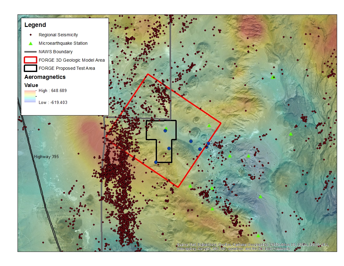
A map with the Coso West Flank FORGE test area outlined, along with regional seismicity, the aeromagnetic data set and the area currently being utilized for the creation of the 3D model.
Search relevance: 51.78 | Views last month: 0 -
The U. S. Geological Survey (USGS) makes long-term seismic hazard forecasts that are used in building codes. The hazard models usually consider only natural seismicity; non-tectonic (man-made)...
Search relevance: 44.27 | Views last month: 1 -
The U. S. Geological Survey (USGS) makes long-term seismic hazard forecasts that are used in building codes. The hazard models usually consider only natural seismicity; non-tectonic (man-made)...
Search relevance: 44.02 | Views last month: 0 -
The U. S. Geological Survey (USGS) makes long-term seismic hazard forecasts that are used in building codes. The hazard models usually consider only natural seismicity; non-tectonic (man-made)...
Search relevance: 43.41 | Views last month: 0 -
The U. S. Geological Survey (USGS) makes long-term seismic hazard forecasts that are used in building codes. The hazard models usually consider only natural seismicity; non-tectonic (man-made)...
Search relevance: 43.14 | Views last month: 1 -
The U. S. Geological Survey (USGS) makes long-term seismic hazard forecasts that are used in building codes. The hazard models usually consider only natural seismicity; non-tectonic (man-made)...
Search relevance: 42.61 | Views last month: 0 -
The U. S. Geological Survey (USGS) makes long-term seismic hazard forecasts that are used in building codes. The hazard models usually consider only natural seismicity; non-tectonic (man-made)...
Search relevance: 42.30 | Views last month: 0 -
The U. S. Geological Survey (USGS) makes long-term seismic hazard forecasts that are used in building codes. The hazard models usually consider only natural seismicity; non-tectonic (man-made)...
Search relevance: 41.78 | Views last month: 1 -
The U. S. Geological Survey (USGS) makes long-term seismic hazard forecasts that are used in building codes. The hazard models usually consider only natural seismicity; non-tectonic (man-made)...
Search relevance: 40.71 | Views last month: 0 -
Datasets and information used to characterize the subsurface of Newberry and support modeling efforts. Includes sources for well logs, earthquakes, maps & cross-sections, and LiDAR/DEM
Search relevance: 35.30 | Views last month: 0 -
DEEPEN stands for DE-risking Exploration of geothermal Plays in magmatic ENvironments. As part of the development of the DEEPEN 3D play fairway analysis (PFA) methodology for magmatic plays...
Search relevance: 30.53 | Views last month: 0 -
This archived dataset contains magnetic and gravity imaging data for the Appalachian Basin, compiled using Poisson Wavelet Multiscale Edge Detection, referred to as 'worm' for brevity, and stored...
Search relevance: 30.19 | Views last month: 0 -
This submission of Utilization Analysis data to the Geothermal Data Repository (GDR) node of the National Geothermal Data System (NGDS) is in support of Phase 1 Low Temperature Geothermal Play...
Search relevance: 28.62 | Views last month: 0 -
Seismicity catalogs, gridded seismic hazard curve data, gridded ground motion data, and mapped gridded ground motion values are available for the 2016 One-Year Seismic Hazard Forecast for the...
Search relevance: 28.22 | Views last month: 1 -
This submission contains information used to compute the risk factors for the GPFA-AB project. The risk factors are natural reservoir quality, thermal resource quality, potential for induced...
Search relevance: 26.72 | Views last month: 0 -
DEEPEN stands for DE-risking Exploration of geothermal Plays in magmatic ENvironments. Part of the DEEPEN project involved developing and testing a methodology for a 3D play fairway analysis...
Search relevance: 20.48 | Views last month: 0 -
The data is associated to the Fallon FORGE project and includes mudlogs for all wells used to characterize the subsurface, as wells as gravity, magnetotelluric, earthquake seismicity, and...
Search relevance: 20.04 | Views last month: 0
