
Found 129 datasets matching "thermal anomaly".
-
The Coral Reef Temperature Anomaly Database (CoRTAD) is a collection of sea surface temperature (SST) and related thermal stress metrics, developed specifically for coral reef ecosystem...
Search relevance: 108.36 | Views last month: 0 -
Version 6 of the Coral Reef Temperature Anomaly Database (CoRTAD) is a global, 4 km, sea surface temperature (SST) and related thermal stress metrics dataset for 1982-01-02 to 2022-12-30. The...
Search relevance: 107.08 | Views last month: 0 -
The Coral Reef Temperature Anomaly Database (CoRTAD) is a collection of sea surface temperature (SST) and related thermal stress metrics, developed specifically for coral reef ecosystem...
Search relevance: 107.03 | Views last month: 0 -
The Coral Reef Temperature Anomaly Database (CoRTAD) is a collection of sea surface temperature (SST) and related thermal stress metrics, developed specifically for coral reef ecosystem...
Search relevance: 102.78 | Views last month: 0 -
The Coral Reef Temperature Anomaly Database (CoRTAD) is a collection of sea surface temperature (SST) and related thermal stress metrics, developed specifically for coral reef ecosystem...
Search relevance: 100.11 | Views last month: 0 -
Critical and trace element data for drill cuttings from Beowawe, Dixie Valley, and Roosevelt Hot Springs-Blundell geothermal production fields, for drill cuttings from Uinta basin producing...
Search relevance: 84.49 | Views last month: 0 -
This shapefile contains location and attribute data for a shallow (2 meter) temperature survey conducted by Geothermal Technical Partners, Inc. during late 2008 and early 2009. Temperatures at 2m...
Search relevance: 69.66 | Views last month: 0 -
CIRES provided polygon shapefiles showing areas of anomalously warm ground, derived from ASTER and LANDSAT remotely sensed thermal infrared imagery. Partly from these anomalies, and partly through...
Search relevance: 53.91 | Views last month: 0 -
Provided here are various forms of the Stanford Thermal Earth Model, as well as the data and methods used for its creation. The predictions produced by this model were visualized in...
Search relevance: 51.43 | Views last month: 0 -
Areas of groundwater discharge are hydrologically and ecologically important, and yet are difficult to predict at the river network scale. Thermal infrared imagery can be used to identify areas of...
Search relevance: 46.95 | Views last month: 1 -
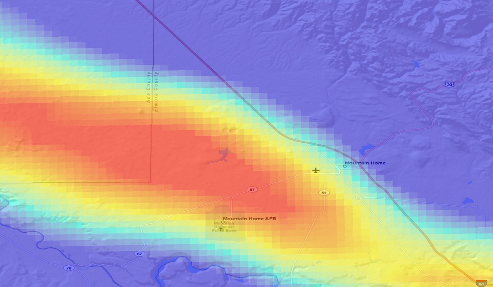
In order to better define the size of the thermal anomaly in the Raft River Valley, Idaho, the U.S. Geological Survey drilled a series of intermediate-depth (nominal 500-ft depth) wells in 1977...
Search relevance: 45.07 | Views last month: 0 -
Data generated from the Alum Innovative Exploration Project, one of several promising geothermal properties located in the middle to upper Miocene (~11-5 Ma, or million years BP) Silver Peak-Lone...
Search relevance: 44.29 | Views last month: 0 -
Note: This "Weakly Anomalous to Anomalous Surface Temperature" dataset differs from the "Anomalous Surface Temperature" dataset for this county (another remotely sensed CIRES product) by showing...
Search relevance: 42.47 | Views last month: 0 -
More than 17 million selected magnetic observations from several orbiting low-altitude satellites are contained in this digital collection. Except for MAGSAT, all the observations are of total...
Search relevance: 42.38 | Views last month: 5 -
The Snake River Plain (SRP), Idaho, hosts potential geothermal resources due to elevated groundwater temperatures associated with the thermal anomaly Yellowstone-Snake River hotspot. Project...
Search relevance: 41.08 | Views last month: 0 -
The Snake River Plain (SRP), Idaho, hosts potential geothermal resources due to elevated groundwater temperatures associated with the thermal anomaly Yellowstone-Snake River hotspot. Project...
Search relevance: 40.91 | Views last month: 0 -
This dataset contains several memos describing geothermal targets outlined by Flint personnel in Colorado. Phase 1 involved an ASTER and LANDSAT thermal infrared imagery assessment conducted by...
Search relevance: 40.76 | Views last month: 0 -
The MODIS/Terra Atmospherically Corrected Surface Reflectance 5-Min L2 Swath 250m, 500m, 1km (MOD09) product is computed from the MODIS Level 1B land bands 1, 2, 3, 4, 5, 6, and 7 (centered at 648...
Search relevance: 39.85 | Views last month: 4 -
The MODIS/Aqua Atmospherically Corrected Surface Reflectance 5-Min L2 Swath 250m, 500m, 1km (MYD09) product is computed from the MODIS Level 1B land bands 1, 2, 3, 4, 5, 6, and 7 (centered at 648...
Search relevance: 39.85 | Views last month: 0 -
MODIS/Aqua Near Real Time (NRT) L2 Surface Reflectance, 5-Min Swath 250m, 500m, and 1km (MYD09). This product is computed from the MODIS Level 1B land bands 1, 2, 3, 4, 5, 6, and 7 (centered at...
Search relevance: 39.85 | Views last month: 0
