
Found 2407 datasets matching "transects".
-
As part of the initial site investigation for the Tanana River near Nenana, Alaska, a set of transects was completed on September 23rd, 2010. Similar to the one done on August 10th, 2010. This...
Search relevance: 120.33 | Views last month: 6 | Published on: 2026-03-23 -
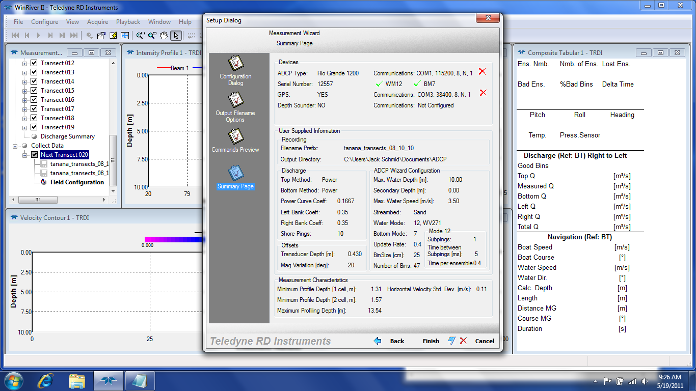
As part of the initial site investigation for the Tanana River near Nenana, Alaska, a set of transects was completed on August 10th, 2010. This data was collected with a Rio Grande 1200 Teledyne...
Search relevance: 108.94 | Views last month: 0 | Published on: 2026-03-23 -
This is a point feature class of high-frequency specific conductance and water temperature measurements at specific points in the South Delta. Specific conductance data was collected for the...
Search relevance: 83.27 | Views last month: 0 | Published on: 2025-07-28 -
Stratum boundaries shapefile for the Central and Western Canadian Arctic Aerial Breeding Waterfowl Survey. Also included is a shapefile of the survey transects and a data table with the transect...
Search relevance: 79.84 | Views last month: 0 | Published on: 2026-03-04 -
This is a MD iMAP hosted service layer. Find more information at http://imap.maryland.gov. To quantify rates of change (erosion or accretion) along coastal and estuarine shorelines in Maryland - ...
Search relevance: 79.72 | Views last month: 2 | Published on: 2025-08-02 -
Botanical survey transects undertaken in the War in the Pacific National Historic Park, Guam, Mariana Islands.
Search relevance: 75.63 | Views last month: 2 | Published on: 2026-01-27 -
Shapefile created by USGS. Channel transects were constructed to be used in evaluating channel widths and channel width variation. Transects were laid out at 0.1 mile intervals along the...
Search relevance: 71.15 | Views last month: 0 | Published on: 2026-03-03 -
This data package contains annual measurements of vegetation cover, species, and height from transects at the Connectivity Modifier (Conmod) Pilot study on the Jornada Experimental Range from...
Search relevance: 71.06 | Views last month: 0 | Published on: 2026-01-27 -
This shapefile denotes the location of underwater photos and video transects taken between 10/23-10/31/12 in Fish Bay and Coral Bay, St. John and the St. Thomas East End Reserve (STEER) in the...
Search relevance: 70.70 | Views last month: 0 | Published on: 2026-04-11 -
This shapefile denotes the location of 399 underwater photos and video transects taken between 3/18 - 3/28/2013 in Fish Bay and Coral Bay, St. John and the St. Thomas East End Reserve (STEER) in...
Search relevance: 69.13 | Views last month: 0 | Published on: 2026-04-11 -
Breton Island, Louisiana Transects with Shoreline Change Rates (Pre-1950s) (Geographic, NAD83) consists of vector transect data that were derived from the Digital Shoreline Analysis System (DSAS)...
Search relevance: 67.79 | Views last month: 1 | Published on: 2026-03-03 -
Access database housing the uplands transect data collected as part of the Rincon Mountain east slope vegetation monitoring project at Saguaro National Park.
Search relevance: 66.65 | Views last month: 0 | Published on: 2026-03-04 -
This data release supports the following publication: Hittle, Elizabeth, 2017, Longshore Water-Current Velocity and the Potential for Transport of Contaminants: A Pilot Study in Lake Erie from...
Search relevance: 66.46 | Views last month: 0 | Published on: 2026-03-03 -
This package contains data from a study that measured long-term soil movement in areas undergoing mesquite invasion on the Jornada Experimental Range from 1933-2011. Data consist of height...
Search relevance: 66.35 | Views last month: 0 | Published on: 2026-01-27 -
Breton Island, Louisiana Transects with Shoreline Change Rates (Post-1950s) (Geographic, NAD83) consists of vector transect data that were derived from the Digital Shoreline Analysis System (DSAS)...
Search relevance: 65.21 | Views last month: 1 | Published on: 2026-03-03 -
Breton Island, Louisiana Transects with Shoreline Change Rates (1869 - 2014) (Geographic, NAD83) consists of vector transect data that were derived from the Digital Shoreline Analysis System...
Search relevance: 65.21 | Views last month: 0 | Published on: 2026-03-03 -
Benthic habitats of the moderate-depth marine environment in and around the Virgin Islands Coral Reef National Monument were mapped using a combination of semi-automated classification and visual...
Search relevance: 65.08 | Views last month: 0 | Published on: 2026-01-27 -
Breton Island, Louisiana Transects with Shoreline Change Rates (Post Hurricane Katrina) (Geographic, NAD83) consists of vector transect data that was derived from the Digital Shoreline Analysis...
Search relevance: 65.03 | Views last month: 0 | Published on: 2026-03-03 -
Cross-shore transects (CSTs) developed for Coastal Storm Model (CoSMoS) work in Northern California 3.2 are presented. 3,528 CSTs are numbered consecutively from 8067 at Golden Gate Bridge to...
Search relevance: 64.86 | Views last month: 1 | Published on: 2026-03-03 -
The data represent 3 replicate measures of linear distance along 30 fixed transects on permanent subtidal monitoring sites around San Nicolas Island, CA. There were six sites, each of which had...
Search relevance: 64.50 | Views last month: 0 | Published on: 2026-03-03
