
Found 24 datasets matching "underwater noise".
-
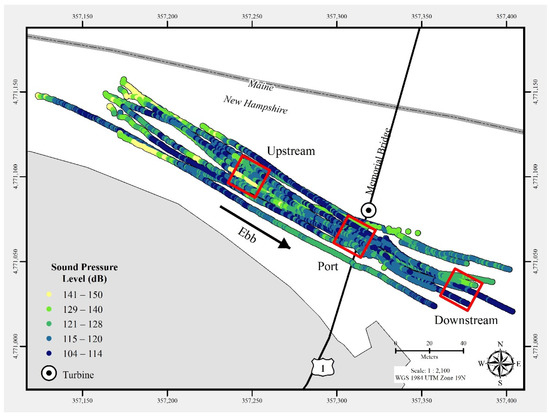
In July 2021, a commercial-off-the-shelf hydrophone was deployed in a free-drifting configuration to measure underwater acoustic emissions and characterize a 25 kW-rated tidal turbine at the...
Search relevance: 163.55 | Views last month: 0 -
This submission contains a public Post Access Report documenting drifting acoustic measurements near ORPC river turbines, an archive of associated report figures in MATLAB .fig format with...
Search relevance: 76.90 | Views last month: 0 -
The repository contains underwater noise measurements and associated metadata collected around C-Power's SeaRay wave energy converter on July 15, 2024 and July 16, 2024 while it was deployed at...
Search relevance: 62.69 | Views last month: 2 -
A digital elevation model (DEM) was created from underwater images collected at Eastern Dry Rocks coral reef near Key West, Florida, in May 2021 using the SQUID-5 camera system. The underwater...
Search relevance: 56.60 | Views last month: 0 -
A digital elevation model (DEM) was created from underwater images collected at Big Pine Ledge (BPL), Florida, in July 2022 using the SfM (Structure-from-Motion) Quantitative Underwater Imaging...
Search relevance: 52.27 | Views last month: 0 -
A digital elevation model (DEM) was created from underwater images collected at Looe Key, Florida, in July 2021 using the SQUID-5 camera system. The underwater images were processed using...
Search relevance: 51.50 | Views last month: 0 -
A digital elevation model (DEM) was created from underwater images collected at Summerland Ledge (SL), Florida, in July 2022 using the SfM (Structure-from-Motion) Quantitative Underwater Imaging...
Search relevance: 51.26 | Views last month: 0 -
A digital elevation model (DEM) was created from underwater images collected at Big Pine Ledge, Florida, in July 2021 using the SQUID-5 camera system. The underwater images were processed using...
Search relevance: 50.59 | Views last month: 0 -
Underwater images collected near Dollar Point in Lake Tahoe, California, were processed using Structure-from-Motion (SfM) photogrammetry techniques into a classified 3D point cloud. The DEM was...
Search relevance: 50.09 | Views last month: 1 -
A digital elevation model (DEM) was created from underwater images collected at Looe Key (LKR), Florida, in July 2022 using the SfM (Structure-from-Motion) Quantitative Underwater Imaging Device...
Search relevance: 48.44 | Views last month: 0 -
Glacier Bay National Park is conducting underwater passive acoustic monitoring to characterize the underwater sound environment including weather generated sounds, biologics, and vessel noise, for...
Search relevance: 48.42 | Views last month: 2 -
A digital elevation model (DEM) was created from underwater images collected at Looe Key (LKR), Florida, in July 2022 using the SfM (Structure-from-Motion) Quantitative Underwater Imaging Device...
Search relevance: 47.51 | Views last month: 0 -
Passive acoustic monitoring of the ocean ambient sound field is a critical aspect of NOAA's mandate for ocean and coastal stewardship. This includes detecting and characterizing: (1) sounds...
Search relevance: 45.35 | Views last month: 1 -
Three-dimensional point clouds (LAZ format) were developed from underwater images collected near Dollar Point in Lake Tahoe, California, and processed using Structure-from-Motion (SfM)...
Search relevance: 42.93 | Views last month: 1 -
This acoustic monitoring program deployed twenty marine acoustic recorders off Canada's east coast between August 2015 and July 2017. The recording protocol was selected to monitor marine mammal...
Search relevance: 40.46 | Views last month: 5 -
The effectiveness of an acoustic barrier to deter the movement of silver carp, Hypophthalmichthys molitrix, and bighead carp, H. noblis, was evaluated. A pond (10 m, x 5 m x 1.2 m) was divided in...
Search relevance: 40.44 | Views last month: 0 -
This dataset contains underwater acoustic measurements collected around the University of Washington's pilot-scale cross-flow tidal turbine deployed at the entrance to Sequim Bay, WA through...
Search relevance: 40.37 | Views last month: 0 -
A three-dimensional point cloud (LAZ format) was developed from underwater images collected at Eastern Dry Rocks coral reef near Key West, Florida, in May 2021 using the SQUID-5 camera system and...
Search relevance: 39.83 | Views last month: 2 -
This data release is part of TEAMER RFTS 2, where the Cooperative Institute for Marine Resources Studies (CIMRS) at Oregon State University is performing hardware and software development and...
Search relevance: 38.90 | Views last month: 0 -
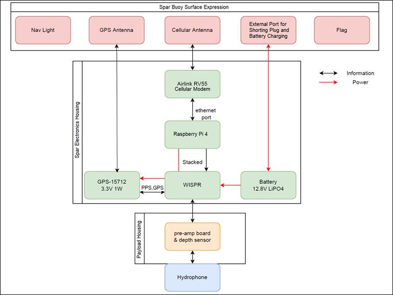
Acoustic data and metadata from Drifting Acoustic Instrumentation SYstem (DAISY) testing in Agate Pass (separating the north end of Bainbridge Island and the Kitsap Peninsula in Puget Sound), WA...
Search relevance: 32.94 | Views last month: 0
