
Found 2036 datasets matching "well location".
-
Utah FORGE has been established to develop, test, and improve the technologies and techniques required to develop EGS-type geothermal resources. Drilling of the first of two deep deviated wells,...
Search relevance: 146.76 | Views last month: 0 -
It contains all the well bottom spots on the RRC GIS map.
Search relevance: 99.56 | Views last month: 0 -
Inventory of all UIC #s for injection wells under RRC jurisdiction; contains permit parameters, latitude and longitude well coordinates.
Search relevance: 99.56 | Views last month: 0 -
This archive contains an Excel spreadsheet with pressure and temperature logs from PacifiCorp well 71-10. This well is in the Blundell Power Plant geothermal well field near Roosevelt Hot Springs,...
Search relevance: 65.64 | Views last month: 0 -
This dataset contains Schlumberger dip meter and neutron density logs for Lu Lu State #1 wild cat well which is located in the Beaver Basin, Beaver County, Utah. There is also a text file with...
Search relevance: 64.67 | Views last month: 0 -
These data tables describe observations made on borehole geophysical logs from 16,200 wells in the Williston Basin. It includes detailed surface hole locations, true vertical depths of formation...
Search relevance: 64.66 | Views last month: 0 -
This is a Utah FORGE well 16A(78)-32 stimulation microseismic detection and event location report from Silixa LLC. The report covers the digital acoustic sensing (DAS) data acquisition and...
Search relevance: 64.20 | Views last month: 0 -
This data release was prepared as part of an agreement between the California Department of Water Resources (DWR) and the United States Geological Survey (USGS) to support the Sustainable...
Search relevance: 61.32 | Views last month: 0 -
This dataset includes position coordinates and elevation information for wells at the WHOLESCALE San Emidio project location. Well positions in the attached file are characterized by UTM...
Search relevance: 57.42 | Views last month: 0 -
A three-dimensional hydrogeologic framework model (3D HFM) of the westernmost western Snake River Plain (WSRP) aquifer system was prepared to represent the subsurface distribution and thickness of...
Search relevance: 50.79 | Views last month: 0 -
This archive contains the input data for the conceptual well locations for the logistic mapping. Data were computed for either the well location or within a buffer area of the well location, as...
Search relevance: 37.04 | Views last month: 0 -
This archive contains the well input data for the logistic regression model for the five-year categories 2000-2004, 2005-2009, 2010-2014, and 2015-2019. Data were collected either at the well...
Search relevance: 36.26 | Views last month: 0 -
This submission includes an Excel spreadsheet containing the Utah FORGE deep well 16A(78)-32 planned trajectory including UTM coordinates, elevations, and depths from the well head to the toe....
Search relevance: 35.77 | Views last month: 0 -
The United States Documented Unplugged Orphaned Oil and Gas Well (DOW) dataset contains 117,672 wells in 27 states. The definition of an orphaned oil or gas well varies across data sources; the...
Search relevance: 35.29 | Views last month: 15 -
This archive contains a GIS point feature shapefile that shows the locations of wells in the general region of the Utah FORGE project, near Roosevelt Hot Springs. This includes Utah FORGE deep...
Search relevance: 34.87 | Views last month: 0 -
The U.S. Geological Survey, in cooperation with Wake County Environmental Services, initiated a comprehensive groundwater resource investigation to better understand the quantity and quality of...
Search relevance: 34.78 | Views last month: 2 -
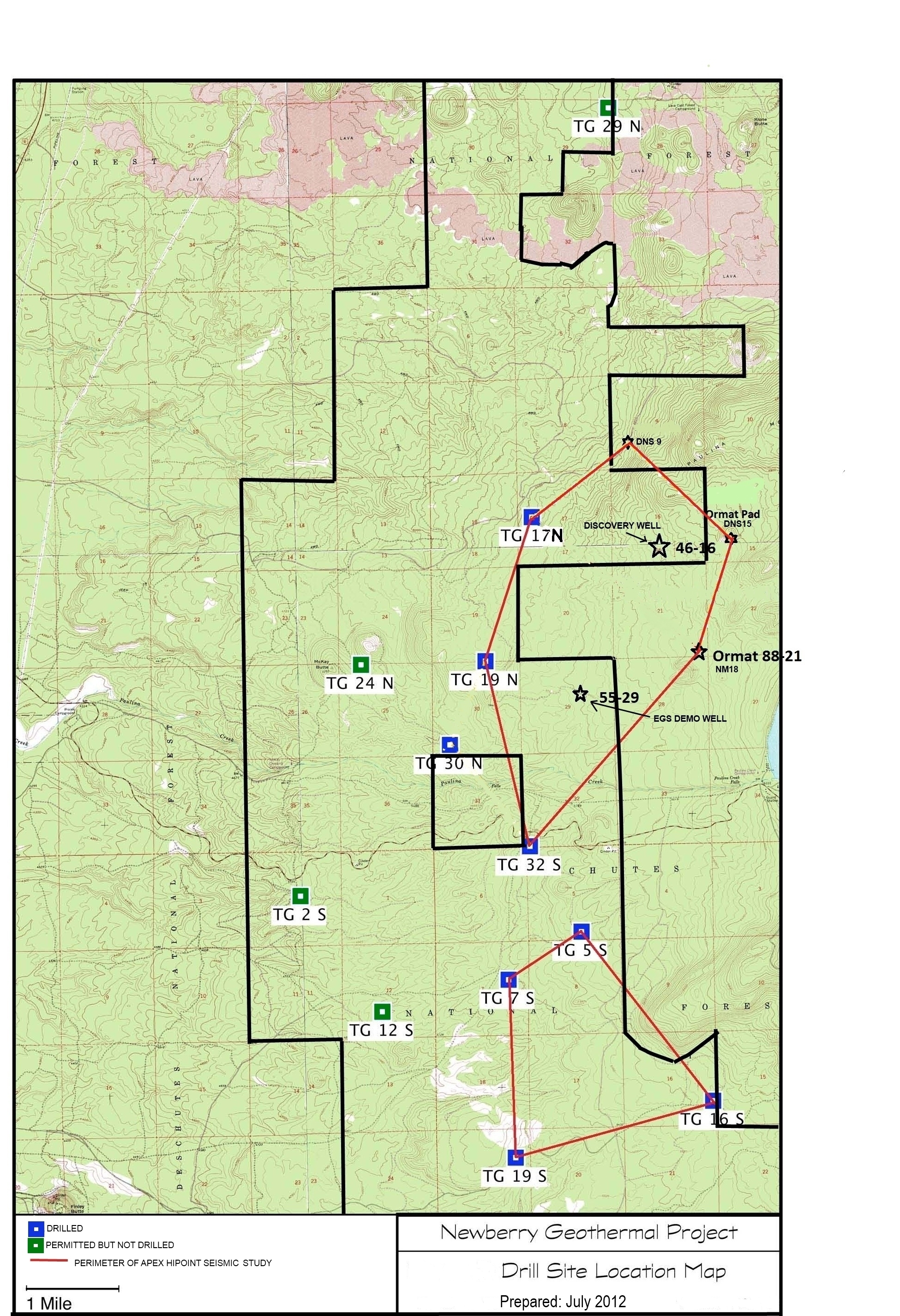
A map showing location of wells permitted, drilled and seismic test, as part of validation of innovative exploration technologies done for the Newberry Volcano project in 2012.
Search relevance: 34.21 | Views last month: 0 -
Contains metadata associated with the wells used in the 2016 Spring Campaign led partially by UW - Madison, LBNL, and LLNL scientists. Included with the well coordinates are the depths to the...
Search relevance: 33.76 | Views last month: 0 -
This dataset includes over 49,000 well records from the state well drillers databases in Minnesota, Wisconsin, and Michigan. Each state well has at a minimum the well depth and a static water...
Search relevance: 33.76 | Views last month: 0
