
Found 1354 datasets matching "west area".
-
The Habitat Blueprint provides a forward-looking framework for NOAA to think and act strategically across programs and with partner organizations to improve coastal and marine habitats for...
Search relevance: 75.75 | Views last month: 1 -
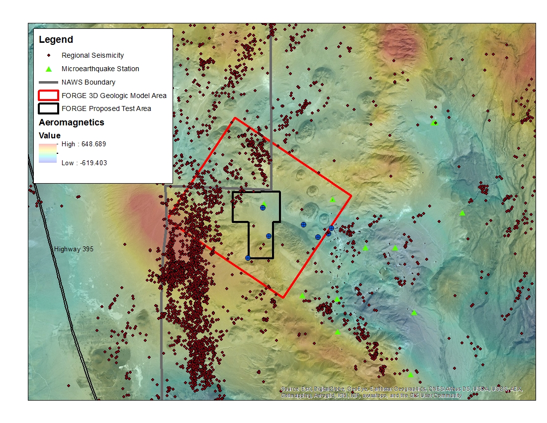
A map with the Coso West Flank FORGE test area outlined, along with regional seismicity, the aeromagnetic data set and the area currently being utilized for the creation of the 3D model.
Search relevance: 74.74 | Views last month: 0 -
Proposed marine reserve area at Kaupulehu in the northern part of the Kona district on the west coast of Hawaii Island. The community proposal includes no-take for 10 years to allow for the reef...
Search relevance: 69.96 | Views last month: 1 -
The TIGER/Line shapefiles and related database files (.dbf) are an extract of selected geographic and cartographic information from the U.S. Census Bureau's Master Address File / Topologically...
Search relevance: 62.79 | Views last month: 1 -
The TIGER/Line shapefiles and related database files (.dbf) are an extract of selected geographic and cartographic information from the U.S. Census Bureau's Master Address File / Topologically...
Search relevance: 62.23 | Views last month: 0 -
The TIGER/Line shapefiles and related database files (.dbf) are an extract of selected geographic and cartographic information from the U.S. Census Bureau's Master Address File / Topologically...
Search relevance: 62.08 | Views last month: 2 -
The TIGER/Line shapefiles and related database files (.dbf) are an extract of selected geographic and cartographic information from the U.S. Census Bureau's Master Address File / Topologically...
Search relevance: 61.76 | Views last month: 0 -
The TIGER/Line shapefiles and related database files (.dbf) are an extract of selected geographic and cartographic information from the U.S. Census Bureau's Master Address File / Topologically...
Search relevance: 59.05 | Views last month: 0 -
The TIGER/Line shapefiles and related database files (.dbf) are an extract of selected geographic and cartographic information from the U.S. Census Bureau's Master Address File / Topologically...
Search relevance: 56.74 | Views last month: 1 -
The TIGER/Line shapefiles and related database files (.dbf) are an extract of selected geographic and cartographic information from the U.S. Census Bureau's Master Address File / Topologically...
Search relevance: 56.74 | Views last month: 0 -
The TIGER/Line shapefiles and related database files (.dbf) are an extract of selected geographic and cartographic information from the U.S. Census Bureau's Master Address File / Topologically...
Search relevance: 55.57 | Views last month: 1 -
This archive package contains data on species composition, density, size, and abundance for coral reef fish as well as coral counts, benthic cover, and macroalga cover in the West Hawaii Habitat...
Search relevance: 55.51 | Views last month: 0 -
The Digital Surficial Geologic-GIS Map of Gauley River National Recreation Area, West Virginia is composed of GIS data layers and GIS tables, and is available in the following GRI-supported GIS...
Search relevance: 55.24 | Views last month: 0 -
The TIGER/Line shapefiles and related database files (.dbf) are an extract of selected geographic and cartographic information from the U.S. Census Bureau's Master Address File / Topologically...
Search relevance: 55.19 | Views last month: 0 -
This resource is a member of a series. The TIGER/Line shapefiles and related database files (.dbf) are an extract of selected geographic and cartographic information from the U.S. Census Bureau's...
Search relevance: 54.59 | Views last month: 0 -
The TIGER/Line shapefiles and related database files (.dbf) are an extract of selected geographic and cartographic information from the U.S. Census Bureau's Master Address File / Topologically...
Search relevance: 54.46 | Views last month: 0 -
The TIGER/Line shapefiles and related database files (.dbf) are an extract of selected geographic and cartographic information from the U.S. Census Bureau's Master Address File / Topologically...
Search relevance: 53.95 | Views last month: 0 -
The TIGER/Line shapefiles and related database files (.dbf) are an extract of selected geographic and cartographic information from the U.S. Census Bureau's Master Address File / Topologically...
Search relevance: 53.95 | Views last month: 0 -
The TIGER/Line shapefiles and related database files (.dbf) are an extract of selected geographic and cartographic information from the U.S. Census Bureau's Master Address File / Topologically...
Search relevance: 53.87 | Views last month: 0 -
The TIGER/Line shapefiles and related database files (.dbf) are an extract of selected geographic and cartographic information from the U.S. Census Bureau's Master Address File / Topologically...
Search relevance: 53.87 | Views last month: 0
