
Found 22 datasets matching "3D simulation".
-
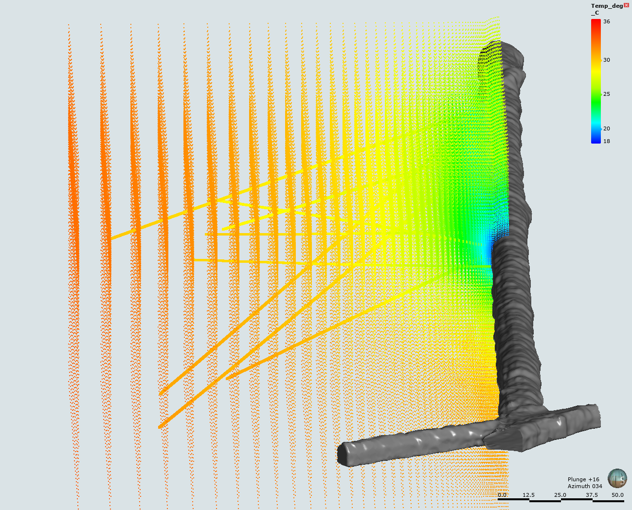
This submission includes an input file, plot file, Fortran conversion file, and 3D data file from the simulation of the temperature profile within the Test Bed #1 of the EGS Collab project. The...
Search relevance: 94.21 | Views last month: 0 -
The included report outlines the creation of three 3D resistivity models that will be used to determine the sensitivity of EM measurements for the hypothetical stimulated reservoir at FORGE as...
Search relevance: 72.32 | Views last month: 0 -
This data release contains a digital geospatial dataset generated by the U.S. Geological Survey under a cooperative agreement with the Water Replenishment District of Southern California to...
Search relevance: 49.72 | Views last month: 1 -
Gravitational radiation waveforms for black hole-neutron star coalescence calculations. The physical input is Newtonian physics, an ideal gas equation of state with varying compressibility...
Search relevance: 49.14 | Views last month: 9 -
The model layer facies grids describe geographic variations in lithology mixtures (facies) used in the 3D petroleum systems model of the Williston Basin. The grids provide constraints on the...
Search relevance: 47.27 | Views last month: 0 -
Virtual Flow Solver - Geophysics (VFS-Geophysics) is a three-dimensional (3D) incompressible Navier-Stokes solver based on the Curvilinear Immersed Boundary (CURVIB) method. The CURVIB is a sharp...
Search relevance: 41.97 | Views last month: 0 -
This dataset contains Global Modeling Initiative (GMI) Chemical Transport Model (CTM) outputs from the four Atom campaigns. GMI simulations of the ATom flight periods have a horizontal resolution...
Search relevance: 40.46 | Views last month: 0 -
This data submission contains GIS raster datasets mapping the visual impacts of the land-based wind turbine fleet in the Contiguous United States (CONUS). Two datasets are included, each...
Search relevance: 38.40 | Views last month: 1 -
This dataset provides daily SnowModel simulation outputs on a 3-km grid for the period 1 September 1980 through 31 August 2020, covering the Core ABoVE Domain. The daily outputs include: air...
Search relevance: 36.38 | Views last month: 0 -
This digital dataset was created as part of a U.S. Geological Survey study, done in cooperation with the Sonoma County Water Agency and the City of Petaluma, to be used as the digital...
Search relevance: 35.63 | Views last month: 2 -
A 3-dimensional (3D) synthetic model, using MODFLOW-NWT and MT3D-USGS, explores the new unsaturated zone heat transport capabilities in MT3D-USGS. Model simulations were used to explore various...
Search relevance: 34.22 | Views last month: 0 -
Contains input scripts, background information, reduced data, and results associated with the discrete element method (DEM) simulations of interface shear tests, plate anchor pullout tests, and...
Search relevance: 32.26 | Views last month: 0 -
The Excel file contains the model input-out data sets that where used to evaluate the two-layer soil moisture and flux dynamics model. The model is original and was developed by Dr. Hantush by...
Search relevance: 31.81 | Views last month: 0 -
AeroDyn is a time-domain wind and MHK turbine aerodynamics module that can be coupled into the FAST version 8 multi-physics engineering tool to enable aero-elastic simulation of horizontal-axis...
Search relevance: 30.22 | Views last month: 0 -
This digital dataset contains the percentage of coarse-grained deposits in wells in 15 meter increments and the percentage of coarse-grained deposits in texture model lattice points interpolated...
Search relevance: 27.44 | Views last month: 0 -
This dataset contains projections of shoreline change and uncertainty bands across California for future scenarios of sea-level rise (SLR). Projections were made using the Coastal Storm Modeling...
Search relevance: 27.43 | Views last month: 3 -
This dataset includes elevation-based probability and depth statistics for estimating inundation under various sea-level rise and high tide flooding scenarios in and around the National Park...
Search relevance: 27.43 | Views last month: 2 -
This digital dataset contains the categories used to classify the basin-fill deposits in the Central Valley as either coarse-grained or fine-grained deposits. This classification was used to...
Search relevance: 27.40 | Views last month: 0 -
This dataset includes elevation-based probability and depth statistics for estimating inundation under various sea-level rise and high tide flooding scenarios in and around the National Park...
Search relevance: 27.00 | Views last month: 0 -
This dataset contains projections of shoreline change and uncertainty bands for future scenarios of sea-level rise (SLR). Scenarios include 25, 50, 75, 100, 150, 200, and 300 centimeters (cm) of...
Search relevance: 25.39 | Views last month: 0
